


We’ve decided to give all of our faithful blog readers a hint to help you along in our most recent Mystery Map Competition. Think of it as an early holiday gift or a generous helping of Thanksgiving leftovers. This map shows some kind of election data. That’s why Scott had to get the data from the […]
Second Annual Tofurky Map
Got travel plans for Thanksgiving Break? Or maybe you’re just spending a few quiet days on campus? Or even better, pitching a tent in the SAL! In any case, we hope that you’ll contribute to our Tofurkey Map (see form below), a tradition started by former Post-Bac Fellow Victoria to document where and how Smithies […]
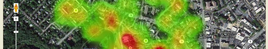
November Mystery Map
In celebration of Geo Week and GIS Day, we’re happy to announce another Mystery Map competition! Scott put together this map after paying a visit to the city clerk earlier this week. Click here for a higher resolution version of the map (in PDF format). (Read about October Mystery Map/Data answer)
Fall 2015 Mystery Map Data Revealed!
Members of the Smith Community seem quite adept at interpreting LiDAR Point Cloud Cross Sections! Nearly eight (80) folks viewed the challenge and eight (8) submitted answers. Of those, five were completely correct, and the remaining three missed one or two. Surprisingly, the Cutter-Ziskind profile (C) was mistaken most often with answers of Mendenhal, and Sabin-Reed/McConnell. The […]
Mapathon for Afghanistan and Pakistan
PLEASE NOTE: The mapathon has been rescheduled to Thursday (11/19) from 6:30-9pm so that it does not conflict with a student-organized sit-in happening on Wednesday from 1pm-midnight. On Thu, 11/19, from 6:30-9pm, we’ll be hosting a mapathon to aid ongoing humanitarian relief efforts in Afghanistan and Pakistan following a large earthquake that occurred on Oct […]
QGIS Workshop: Tues (10/27) and Thurs (10/29)
The Spatial Analysis Lab will be holding a two-part workshop on QGIS next week from 4-5pm on Tuesday, Oct 27 and Thursday, Oct 29. QGIS is a free, open-source alternative to ArcGIS. Q does not require any kind of license and is compatible with Macbooks, so it is a great tool for those who are just starting […]
Fall 2015 Mystery Map-Data
We have cool, shiny new LiDAR data to play with in the Spatial Analysis Lab. These data were captured in December 2013, but we did not receive the final product until earlier this summer. We’ll provide more details about LiDAR, and our plans for processing and analysis after the Mystery Map competition is complete. Until […]
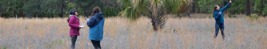
GPS Workshop
We’re happy to announce the first workshop of the fall in the Spatial Analysis Lab’s workshop series! Join us in the SAL to learn about a technology which helps biologists track wildlife, helps archaeologists survey historical sites, and powers self-driving cars, among many other applications. The workshop will take place in two 1-hr sessions: Tues, Oct 20 […]
QGIS Webinar – Wed 10/21
We learned today that our neighbors to the north at the Vermont Center for Geographic Information are hosting a QGIS webinar next Wednesday, Oct 21, from 3-4pm. QGIS is a free, open-source alternative to ArcGIS. Since Q does not require any kind of license and is compatible with Macbooks, it is a great tool for those […]
September Update
The days are getting colder, but things are sure starting to heat up in the SAL as the new school year unfolds! Here’s some of our most recent activity: 1. Class Support 2. Student Support 3. Faculty Support 4. Campus Connections 1. Class Support We helped Prof. Camille Washington-Ottombre introduce her class Environmental Integration I: Perspectives […]