Nepal Earthquake Response Mapping Follow-up Workshop

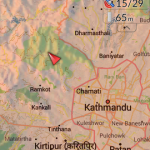
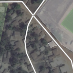
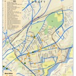
In response to the recent earthquakes in Nepal the Humanitarian OpenStreetMap Team (HOT) has provided an online mapping platform that allows volunteers to help map the infrastructure of the areas in Nepal effected by the earthquakes. Mapping road networks and structures is critically important to help responders navigate the area to provide assistance to those in […]

Nepal Earthquake Response Workshop Well Attended in the Week Before Finals

The Humanitarian OpenStreetMap Team has developed a project called MapGive, which allows volunteers to populate maps in parts of the world where mapping resources are limited. The idea originated following the 2010 earthquake in Haiti when mapping the island’s infrastructure through GPS surveying on foot proved too dangerous and not fast enough. As an alternative OpenStreetMap provided a […]

Ebola Mapping Workshop Packs Room

On Wednesday night the Spatial Analysis Lab hosted workshop instructor Teresa Clary to lead an 90 minute session on Ebola First Responder Mapping with OpenStreetMap. The workshop was heavily attended, pushing the SAL and its computer capacity to the limits. The Humanitarian OpenStreetMap Team has developed a project called MapGive, which encourages volunteers to help […]

Ebola First Responder Mapping Workshop

Wednesday October 8, 7:00 pm in the Spatial Analysis Lab (Sabin-Reed 104) How can you help the Red Cross, Doctors Without Borders, the World Health Organization, and others fight the Ebola epidemic in West Africa?  By attending a free workshop to learn how to edit the map data necessary to coordinate the response effort.  Once […]

Digital Dirt – Managing Botanic Garden Data

The Spatial Analysis Lab is working with the Smith College Botanic Garden to develop an open and robust data model based on the fine work by the Alliance for Public Gardens GIS (APGG).   This effort began as a tiny seed almost 10 years ago, but languished without light and nourishment.  Now, conditions seem ripe to […]

Food Bank Mapping

The Food Bank of Western Massachusetts sought mapping and analysis support from the Spatial Analysis Lab during the summer of 2010.  The project is currently on hold, but you can view some of the initial map products below.  Sarah Motti ’10 provided assistance on the project during her summer employment in the SAL. In many […]

Bike Trail Mapping

The Spatial Analysis Lab (SAL) recently finished the 2011 version of the “Easthampton ~ Northampton Trail & Bicycle Map” for the Friends of Northampton (MA) Trails and Greenways (FNTG) organization.  The 2011 series marks the third iteration of the map series which started back in 2006.  The Bike Map series represents countless hours of effort […]

Healthy Communities

The Spatial Analysis Lab provided mapping and spatial analysis to Cooley Dickinson Hospital (Northampton, MA) as part of their 2011 Community Health Assessment report.