The Spatial Analysis Lab is excited to offer another set of workshops– new and old– for Spring 2020! Take a look at the schedule and mark your calendars for more spatial learning. Please give us a heads up by registering for the workshops that interest you. Snacks will be provided! Drone Ethics: Creating a […]
Category Archives: Teaching
Upcoming Spring 2018 Workshops
The grand reveal: the spring 2018 workshop schedule! All workshops are held in the Lab, Sabin-Reed 104. We like to offer a variety of workshops each semester, so we can also host tailored workshops for your group or department. If interested, please contact sal@smith.edu. Please note that two workshops require pre-registration — you can sign-up […]
Upcoming Fall 2017 Workshops!
Communicating Data with Maps October 12, 2017 (Thursday) 4:00 – 5:00 An introduction to the basics for visualizing your data in a map designed for print. Register Humanitarian Mapping for Recent Hurricanes October 16, 2017 (Monday) 4:00 – 5:00 Contribute to disaster response by identifying infrastructure in satellite imagery to inform humanitarians for effective […]
Story Maps in the Classroom
Maps are increasingly popular as storytelling tools in the world of digital media – just a glance at the homepages of the New York Times, The Atlantic, or the Huffington Post confirms that. We’ve experienced this wave of mapping enthusiasm in the SAL, and it’s already started changing how we teach GIS. Moreso than conventional GIS maps, Story […]
QGIS Webinar – Wed 10/21
We learned today that our neighbors to the north at the Vermont Center for Geographic Information are hosting a QGIS webinar next Wednesday, Oct 21, from 3-4pm. QGIS is a free, open-source alternative to ArcGIS. Since Q does not require any kind of license and is compatible with Macbooks, it is a great tool for those […]
Senior Week Workshops
Calling all aspiring cartographers and spatial thinkers! Interested in developing your map-making skills? Have some spare time during Senior Week? The Spatial Analysis Lab would like to invite Smith students, faculty, staff, and community to join us for a series of informal mapping workshops Tuesday – Friday of Senior Week (5/12-5/15). The workshops are open […]

Interterm Course 2015 — Recap
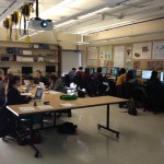
The Spatial Analysis Lab was excited to kick of 2015 with an intro to GIS interterm course in the first week of January Term! 14 students joined us in the SAL for 5 days of GIS exploration with ArcGIS. The course was structured around the development of key GIS skills. Each day focused on one or […]
2015 Interterm Course Offering
In 2015 the Spatial Analysis Lab will instruct a one week Interterm class open to all students, faculty, staff, and Northampton community members. The course will be taught in the first week of Interterm (Jan 5th – Jan 9th) from 1-3pm each day. The structure will be somewhat informal and may end early or stretch […]
Last Week Review (October 13th-17th)
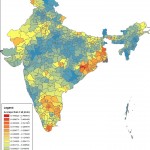
Participations from the SAL during the week of October 13th-17th: 1. Lying with Maps: initial lab session with ENV311 2. Meeting with Lewis Global Studies Center about Study Abroad data 3. Ebola Mapping Workshop at Amherst College 4. Finalized India Rainfall Maps with Economics Professor Vis Taraz 5. One-on-one sessions with “mappers” from Study of […]
Last Week in Review (10/5 – 10/10)
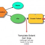
The highlights of last week’s work in the Spatial Analysis Lab, with additional details provided below: – Meeting with Margaret Bruzelius and STRIDE students – Zebra Fish project updates – Omeka and Scalar research – OpenStreetMap Workshop for Ebola Relief Workers – Data Science guest lecturing Margaret Bruzelius and STRIDE students: […]