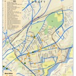
As the pandemic began its sweep through the United States we have seen incredible mutual aid responses pop up all over the world, and in our local communities. And what better way to visualize those efforts than a map! The local Pioneer Valley mutual aid network reached out in need of a map to help […]
Category Archives: Health
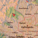
Nepal Earthquake Response Workshop Well Attended in the Week Before Finals
The Humanitarian OpenStreetMap Team has developed a project called MapGive, which allows volunteers to populate maps in parts of the world where mapping resources are limited. The idea originated following the 2010 earthquake in Haiti when mapping the island’s infrastructure through GPS surveying on foot proved too dangerous and not fast enough. As an alternative OpenStreetMap provided a […]

Last Week Review (10/20-10/24)
Happy Fall! The highlights from last week’s work in the SAL are as follows: 1. GPS Lab with Professor Ninian Stein’s ENV 201/202 2. Ebola First Responder Social Mapping Night 3. Zebra Fish project continues 4. Coffee machine mapping survey conducted 5. Continued SWG 230 individual meetings 6. Digitizing Coral Reef Mounds 1. GPS Lab […]
Ebola Mapping Workshop Packs Room
On Wednesday night the Spatial Analysis Lab hosted workshop instructor Teresa Clary to lead an 90 minute session on Ebola First Responder Mapping with OpenStreetMap. The workshop was heavily attended, pushing the SAL and its computer capacity to the limits. The Humanitarian OpenStreetMap Team has developed a project called MapGive, which encourages volunteers to help […]
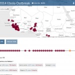
Ebola First Responder Mapping Workshop
Wednesday October 8, 7:00 pm in the Spatial Analysis Lab (Sabin-Reed 104) How can you help the Red Cross, Doctors Without Borders, the World Health Organization, and others fight the Ebola epidemic in West Africa? By attending a free workshop to learn how to edit the map data necessary to coordinate the response effort. Once […]
GIS and Community Health Planning Conference
Papers presented at the University at Albany School of Public Health 7th annual GIS and Public Health conference are now available and include: “All Public Health is Local” : The Community Perspective on GIS and Public Health Russell Kirby, University of South Florida Creating Community Health Indicators Using Spatial Smoothing, Aggregation and Masking Thomas Talbot, […]
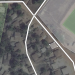
Food Bank Mapping
The Food Bank of Western Massachusetts sought mapping and analysis support from the Spatial Analysis Lab during the summer of 2010. The project is currently on hold, but you can view some of the initial map products below. Sarah Motti ’10 provided assistance on the project during her summer employment in the SAL. In many […]