Q&A COVID-19 related mapping resources Designing & Collecting Data with Survey123 4/16 Thursday 4:00-5:00 Tutorial & Recording First of a 4 part series on designing surveys to capture and share crowdsourced map data. The Spatial Analysis Lab (SAL) will guide you through the process of creating a form, capturing geographic data, generating a map, and […]
Category Archives: Workshop
Spring 2020 Workshops
The Spatial Analysis Lab is excited to offer another set of workshops– new and old– for Spring 2020! Take a look at the schedule and mark your calendars for more spatial learning. Please give us a heads up by registering for the workshops that interest you. Snacks will be provided! Drone Ethics: Creating a […]
Upcoming Fall 2018 Workshops
Web Tools for Creating Fantasy Maps October 23, 2018 (Tuesday) 4:00–5:00 Explore tools to make maps of imaginary landscapes in preparation for Halloween. Web-mapping with ArcGIS Online November 6 (Tuesday) 4:00–5:00 Learn how to make interactive maps with ArcGIS Online. Making Story Maps November 12 (Monday) 4:00–5:00 A compelling visual storytelling platform that combines […]
Maps that Engage and Promote Change Workshop – May 14 & 17, 2018
Learn to create maps that affect social change with design thinking principles at the Maps that Engage and Promote Change Workshop this coming week. Please register here. On Day One: (Monday, May 14 in the Design Thinking Studio – Capen Annex) Learn about the lineages of cartography with particular emphasis on critical cartography and counter-mapping […]
Upcoming Spring 2018 Workshops
The grand reveal: the spring 2018 workshop schedule! All workshops are held in the Lab, Sabin-Reed 104. We like to offer a variety of workshops each semester, so we can also host tailored workshops for your group or department. If interested, please contact sal@smith.edu. Please note that two workshops require pre-registration — you can sign-up […]
Upcoming Fall 2017 Workshops!
Communicating Data with Maps October 12, 2017 (Thursday) 4:00 – 5:00 An introduction to the basics for visualizing your data in a map designed for print. Register Humanitarian Mapping for Recent Hurricanes October 16, 2017 (Monday) 4:00 – 5:00 Contribute to disaster response by identifying infrastructure in satellite imagery to inform humanitarians for effective […]
QGIS Workshop: Tues (10/27) and Thurs (10/29)
The Spatial Analysis Lab will be holding a two-part workshop on QGIS next week from 4-5pm on Tuesday, Oct 27 and Thursday, Oct 29. QGIS is a free, open-source alternative to ArcGIS. Q does not require any kind of license and is compatible with Macbooks, so it is a great tool for those who are just starting […]
May in Review
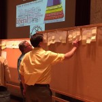
See what the Spatial Analysis Lab (SAL) has been up to in the great month of May: 1. Student Support 2. Faculty Support 3. Campus Connections 4. Outreach 1. Student Support Senior week workshops (5/12 – 5/15): In the week after finals and leading up to graduation, commonly called Senior Week, we hosted a series of informal […]
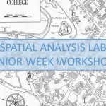
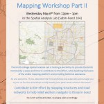
Senior Week Workshops
Calling all aspiring cartographers and spatial thinkers! Interested in developing your map-making skills? Have some spare time during Senior Week? The Spatial Analysis Lab would like to invite Smith students, faculty, staff, and community to join us for a series of informal mapping workshops Tuesday – Friday of Senior Week (5/12-5/15). The workshops are open […]
Nepal Earthquake Response Mapping Follow-up Workshop
In response to the recent earthquakes in Nepal the Humanitarian OpenStreetMap Team (HOT) has provided an online mapping platform that allows volunteers to help map the infrastructure of the areas in Nepal effected by the earthquakes. Mapping road networks and structures is critically important to help responders navigate the area to provide assistance to those in […]