Nepal Earthquake Response Workshop Well Attended in the Week Before Finals

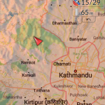
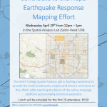
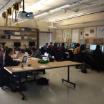
The Humanitarian OpenStreetMap Team has developed a project called MapGive, which allows volunteers to populate maps in parts of the world where mapping resources are limited. The idea originated following the 2010 earthquake in Haiti when mapping the island’s infrastructure through GPS surveying on foot proved too dangerous and not fast enough. As an alternative OpenStreetMap provided a […]

Nepal Earthquake Response Mapping Workshop

In response to Saturday’s earthquake in Nepal the Humanitarian OpenStreetMap Team (HOT) has provided an online mapping platform that allows volunteers to help map the infrastructure of the areas in Nepal effected by the earthquake. Mapping road networks and structures is critically important to help responders navigate the area to provide assistance to those in […]

Spring ’15 Workshop Offerings

Workshops offered by the SAL in spring 2015 — together they provide an introduction to mapping and GIS (Geographic Information System), and separately provide skills for particular GIS tools and skills — mapping addresses data, using GPS unit to collect data, etc. Note: most of our workshops can be taken as stand-alone workshops, however the workshops that […]

2015 Interterm Course Offering

In 2015 the Spatial Analysis Lab will instruct a one week Interterm class open to all students, faculty, staff, and Northampton community members. The course will be taught in the first week of Interterm  (Jan 5th – Jan 9th) from 1-3pm each day. The structure will be somewhat informal and may end early or stretch […]

Last Week Review (10/20-10/24)

Happy Fall! The highlights from last week’s work in the SAL are as follows: 1. GPS Lab with Professor Ninian Stein’s ENV 201/202 2. Ebola First Responder Social Mapping Night 3. Zebra Fish project continues 4. Coffee machine mapping survey conducted 5. Continued SWG 230 individual meetings 6. Digitizing Coral Reef Mounds 1. GPS Lab […]

Last Week in Review (10/5 – 10/10)

The highlights of last week’s work in the Spatial Analysis Lab, with additional details provided below: –          Meeting with Margaret Bruzelius and STRIDE students –          Zebra Fish project updates –          Omeka and Scalar research –          OpenStreetMap Workshop for Ebola Relief Workers –          Data Science guest lecturing Margaret Bruzelius and STRIDE students: […]

Ebola Mapping Workshop Packs Room

On Wednesday night the Spatial Analysis Lab hosted workshop instructor Teresa Clary to lead an 90 minute session on Ebola First Responder Mapping with OpenStreetMap. The workshop was heavily attended, pushing the SAL and its computer capacity to the limits. The Humanitarian OpenStreetMap Team has developed a project called MapGive, which encourages volunteers to help […]

Ebola First Responder Mapping Workshop

Wednesday October 8, 7:00 pm in the Spatial Analysis Lab (Sabin-Reed 104) How can you help the Red Cross, Doctors Without Borders, the World Health Organization, and others fight the Ebola epidemic in West Africa?  By attending a free workshop to learn how to edit the map data necessary to coordinate the response effort.  Once […]

Fall 2014 Workshop Sign-up

The Spatial Analysis Lab hosted its first set of GIS-related workshops for the students, faculty, staff, and community in September. A second set of workshops can be offered later in the semester if the demand is high enough. The form to express interest in participating in a workshop can be found here. Please take a […]

Fall 2014 Workshops

The following workshops are offered by the Spatial Analysis Lab this fall.  Sign up for workshops and express interests for workshop offerings on this form – note: some workshops will only be offered on request. Introduction to Web Mapping Intermediate Web Mapping GPS (Parts I & II) Communicating Data with Maps Web Mapping with Google Products Descriptions […]