April Update

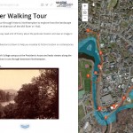
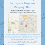
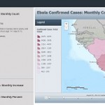
See what work the Spatial Analysis Lab (SAL) supported in the busy month of April 1. Class Support 2. Student Support 3. Campus Connections 4. Outreach   1. Class Support: Environmental Integration II: Collecting and Analyzing Information (ENV201/202): Final Presentations: One of the five student groups in 201/202 decided to focus their final project on looking at […]

Nepal Earthquake Response Mapping Workshop

In response to Saturday’s earthquake in Nepal the Humanitarian OpenStreetMap Team (HOT) has provided an online mapping platform that allows volunteers to help map the infrastructure of the areas in Nepal effected by the earthquake. Mapping road networks and structures is critically important to help responders navigate the area to provide assistance to those in […]

March Update

Spatial Analysis Lab work in March 2015 1. Class Support 2. Campus Connections 3. Outreach   1. Class Support ENV201/202: In the first two weeks of March we hosted Professor Camille Washington-Ottombre’s class Environmental Integration II: Collecting and Analyzing Information (ENV201/202) for a series of class sessions. The six class sessions were split into two labs, one per […]

Commercial Drones in Our Backyards?

Please join us for our Commercial Drones in Our Backyards event on Wednesday, March 4th, 2015 from 7:00 – 9:00 PM in John M. Greene Hall, Smith College Campus. Consider: Will drones darken our skies?  Are we subject to staying indoors if a drone flight is in our neighborhood? Will academics have space and opportunity to teach […]