As the pandemic began its sweep through the United States we have seen incredible mutual aid responses pop up all over the world, and in our local communities. And what better way to visualize those efforts than a map! The local Pioneer Valley mutual aid network reached out in need of a map to help […]
Category Archives: Featured
Featured stories that represent the best of the Spatial Analysis Lab
Documentary Video – Research trip to St. Catherines Island
[advanced_iframe securitykey=”5bc49ba0db168937774fd40d43b1f0f57eecc76d” src=”https://player.vimeo.com/video/212575403″ width=”640″ height=”360″ frameborder=”0″ webkitallowfullscreen mozallowfullscreen allowfullscreen ] We plan to offer future courses and research trips harnessing drone technology. Please visit our sister site dedicated to DroneThinking at Smith College Students on the trip included: Emma Becker Asmita Gautam Susannah Howard Anastasia Konefal Jasmine Pacheco-Ramos Emily Wert Alexandra Widstrand (co-instructor) Instructors were […]
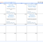
Spring ’15 Workshop Offerings
Workshops offered by the SAL in spring 2015 — together they provide an introduction to mapping and GIS (Geographic Information System), and separately provide skills for particular GIS tools and skills — mapping addresses data, using GPS unit to collect data, etc. Note: most of our workshops can be taken as stand-alone workshops, however the workshops that […]
Ebola Mapping Workshop Packs Room
On Wednesday night the Spatial Analysis Lab hosted workshop instructor Teresa Clary to lead an 90 minute session on Ebola First Responder Mapping with OpenStreetMap. The workshop was heavily attended, pushing the SAL and its computer capacity to the limits. The Humanitarian OpenStreetMap Team has developed a project called MapGive, which encourages volunteers to help […]
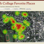
Smith College Favorite Places App
Now in the wild and accepting memories, the Smith College Favorite Places App. Our intention is to explore how Smith Campus Space transforms to Place. No one denies the beauty of our campus, but we want to know what makes a Smith space special or a favorite. As these spaces become invested with […]
Smith College Rail System
Geo-artist Elena Terhune ’14 created this awesome map of an imagined Smith College Subway System. Check it out, and read what she has to say about the process of creating it: “Especially in the colder winter weather, we have all idly wished for some way to travel quickly and warmly. Smith’s Spatial Analysis Lab heard you, […]
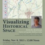
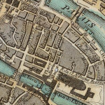
Visualizing Historical Space
Great opportunity to learn about Historical GIS (HGIS) from one of the leading thinkers in the field. Anne Knowles from Middlebury College will be on campus this Friday, November 8th to discuss her work on visualizing the Battle of Gettysburg. Explore the online map for a little preview: A Cutting Edge Second Look at the Battle […]
Digital Humanities Workshop Recap
On Monday and Tuesday, August 13-14, the Smith Spatial Analysis Lab teamed up with Amherst College to host a workshop for Five College faculty entitled Spatial Techniques for the Digital Humanities. We had a great two days of discussion, learning, and collaboration, as workshop participants and instructors alike worked through eight themed sessions focusing on […]
Spatial Techniques for Digital Humanities
In collaboration with Amherst College, the Spatial Analysis Lab is developing a spatially themed workshop titled “Spatial Techniques for the Digital Humanities“. The workshop is part of the Five College Digital Humanities Initiative which promises to enrich curricula and scholarship through digital humanities projects. The workshop also builds on previous and continued collaboration to […]
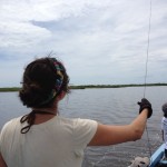
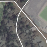
Go Fly a Kite
I now have a good answer to that common question – “What did you do on Summer Vacation”? The answer is “I flew kites in Belize”. A fun answer, but this was no vacation. It was actually quite a bit of work, but our efforts at capturing aerial imagery from a kite platform worked […]