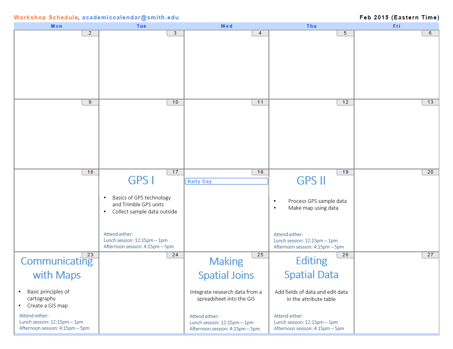
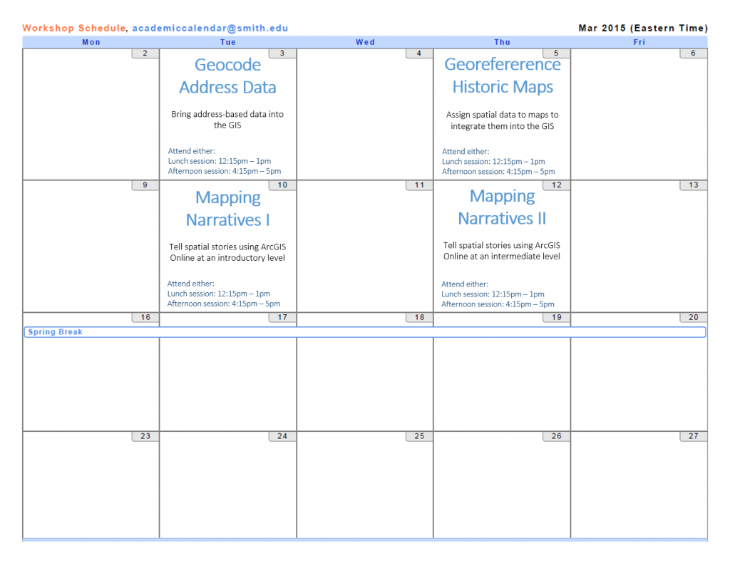
Workshops offered by the SAL in spring 2015 — together they provide an introduction to mapping and GIS (Geographic Information System), and separately provide skills for particular GIS tools and skills — mapping addresses data, using GPS unit to collect data, etc.
Note: most of our workshops can be taken as stand-alone workshops, however the workshops that are sets (with a part I and II) are recommended to be taken together in sequence.
Click here to view the documents used in each workshop
Please sign-up in advance for available workshops
All workshops are open to students, faculty, and staff and will be offered at lunch (12:15-1pm) and in the afternoon (4:15-5PM) on the day they are offered. Feel free to attend either session.
Workshop Descriptions
GPS (Parts I & II)
Join the Spatial Analysis Lab’s GPS Workshop to learn how to use GPS units, optimize the accuracy of your GPS data, and process the data into a finished map product! Learn how to use our mapping grade Trimble Juno units in the workshop. The skills and concepts taught are also applicable to other GPS systems, including Garmin GPS units and smartphone / tablet devices.
The GPS Workshop has two parts. In Part I, we will discuss data collection planning and how to operate the GPS units, and head outside to collect a sample dataset. (45 minutes)
In Part II, we’ll process the GPS data into a shapefile (map data file that can be visualized in GIS software) and make a map of the GPS positions in ArcGIS. (45 minutes)
Communicating Data with Maps
Communicating Data with Maps workshop focuses on the principles of cartography: understanding maps as representations that are the products of subjective choices, using colors and symbols to display quantitative and categorical data on a map, and creating “complete” map layouts with a title, legend, scale, etc. After a brief introduction to these three key aspects of cartography, students will discuss the cartographic choices made in some famous maps, then practice making their own map layout with pre-existing data. (45 minutes)
Making Spatial Joins
Spatial Joins make it easy to integrate research data in table form (spreadsheet, etc.) into pre-existing geographic layers in the GIS. We will work on the computers to join sample data — UFO sightings in the US — to a layer of the states to allow us to visualize the data in the map. We can think about individual research and how it might be formatted to carry out this same process. (45 minutes)
Editing Spatial Data
It is an important skill to be able to edit layer data in the GIS. For example, imagine mapping invasive plants on campus and you need to change an erroneously recorded attribute of a particular plant feature. Additionally you may need to add additional points of data to the layer in the GIS to record new sightings of invasive plants. Learn to both edit current feature attributes and to create new map features in this workshop. (45 minutes)
Geocode Address Data
Learn how to transform a spreadsheet of features with address data into a layer in the GIS. This can be useful for a mapping project using address-based data (as opposed to latitude/longitude-based) or for making a map to compliment a data-based project that contains address information. (45 minutes)
Georeference Historic Maps
Learn to assign spatial reference to paper maps or digital maps without known geographic data. We will take a historic map of Northampton and use current landmarks to connect it to a contemporary map of Northampton. After the georeferencing process, the map can be used with other data layers in a GIS, or exported for use in other applications such as Google Maps or Omeka. (45 minutes)
Mapping Narratives I
This workshop will explore the process of visualizing spatial stories using Esri ArcGIS Online platform. We will spend the majority of the time working within the program to cover the basics of using the online platform, including: adding layers in the webmap, editing content display — symbology, pop-ups, labeling. We will also discuss various types of qualitative and quantitative research data and how it might be used in the program to tell a spatial story. (45 minutes)
Mapping Narratives II
The second Mapping Narratives workshop will build on the previous workshop by working on the same narrative project with expanded program capabilities and scope. First we will explore how the data can be further transformed through online spatial analysis tools to illuminate patterns and further enrich our story. The final piece will be moving the produced web maps into the online storymap application to integrate with images, text, and video. See example story map here. (45 minutes)
**The Mapping Narratives I workshop is not required, but highly recommended for participation in the Mapping Narratives II workshop.
Please sign-up for workshops in advance.