What better way to kick off the fall semester with a Mystery Map? The stakes are high–pride and glory, a spot on the Mystery Map Hall of Fame™, and negotiable baked goods. Behold: When you have a guess, submit your answers below. Submissions are accepted until the end of September!
Category Archives: Politics
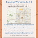
Nepal Earthquake Response Mapping Follow-up Workshop
In response to the recent earthquakes in Nepal the Humanitarian OpenStreetMap Team (HOT) has provided an online mapping platform that allows volunteers to help map the infrastructure of the areas in Nepal effected by the earthquakes. Mapping road networks and structures is critically important to help responders navigate the area to provide assistance to those in […]
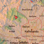
Nepal Earthquake Response Workshop Well Attended in the Week Before Finals
The Humanitarian OpenStreetMap Team has developed a project called MapGive, which allows volunteers to populate maps in parts of the world where mapping resources are limited. The idea originated following the 2010 earthquake in Haiti when mapping the island’s infrastructure through GPS surveying on foot proved too dangerous and not fast enough. As an alternative OpenStreetMap provided a […]
What does your policy look like?
Back in February 2007 I asked one of my student assistants to generate a new map for the mystery map series. At that time I was very interested in visualizing administrative policies manifestation on the landscape. All too often, policies are created and enacted without any insight as to how they will overlay on the […]
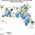
Geography Lesson for Legislators
Illustrating those same data on a map, which ironically, had not been done before, demonstrated the inequities of the proposals and actually helped generate better funding for the disadvantaged districts.