We learned today that our neighbors to the north at the Vermont Center for Geographic Information are hosting a QGIS webinar next Wednesday, Oct 21, from 3-4pm. QGIS is a free, open-source alternative to ArcGIS. Since Q does not require any kind of license and is compatible with Macbooks, it is a great tool for those […]
Tag Archives: Workshop
May in Review
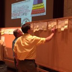
See what the Spatial Analysis Lab (SAL) has been up to in the great month of May: 1. Student Support 2. Faculty Support 3. Campus Connections 4. Outreach 1. Student Support Senior week workshops (5/12 – 5/15): In the week after finals and leading up to graduation, commonly called Senior Week, we hosted a series of informal […]
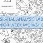
Senior Week Workshops
Calling all aspiring cartographers and spatial thinkers! Interested in developing your map-making skills? Have some spare time during Senior Week? The Spatial Analysis Lab would like to invite Smith students, faculty, staff, and community to join us for a series of informal mapping workshops Tuesday – Friday of Senior Week (5/12-5/15). The workshops are open […]
April Update
See what work the Spatial Analysis Lab (SAL) supported in the busy month of April 1. Class Support 2. Student Support 3. Campus Connections 4. Outreach 1. Class Support: Environmental Integration II: Collecting and Analyzing Information (ENV201/202): Final Presentations: One of the five student groups in 201/202 decided to focus their final project on looking at […]
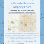
Nepal Earthquake Response Mapping Follow-up Workshop
In response to the recent earthquakes in Nepal the Humanitarian OpenStreetMap Team (HOT) has provided an online mapping platform that allows volunteers to help map the infrastructure of the areas in Nepal effected by the earthquakes. Mapping road networks and structures is critically important to help responders navigate the area to provide assistance to those in […]
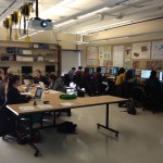
Nepal Earthquake Response Workshop Well Attended in the Week Before Finals
The Humanitarian OpenStreetMap Team has developed a project called MapGive, which allows volunteers to populate maps in parts of the world where mapping resources are limited. The idea originated following the 2010 earthquake in Haiti when mapping the island’s infrastructure through GPS surveying on foot proved too dangerous and not fast enough. As an alternative OpenStreetMap provided a […]
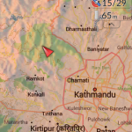
Nepal Earthquake Response Mapping Workshop
In response to Saturday’s earthquake in Nepal the Humanitarian OpenStreetMap Team (HOT) has provided an online mapping platform that allows volunteers to help map the infrastructure of the areas in Nepal effected by the earthquake. Mapping road networks and structures is critically important to help responders navigate the area to provide assistance to those in […]
February 2015 Update (16th – 27th)
It has been a busy two weeks in the Spatial Analysis Lab. Read on to learn about our most recent support of GIS work across campus. 1. Class Support 2. Student Support 3. Faculty Support 4. Outreach 5. Campus Connections 1. Class Support We kicked off our work with Professor Camille Washington-Ottombre’s class Environmental Integration II: Collecting […]
2015 Interterm Course Offering
In 2015 the Spatial Analysis Lab will instruct a one week Interterm class open to all students, faculty, staff, and Northampton community members. The course will be taught in the first week of Interterm (Jan 5th – Jan 9th) from 1-3pm each day. The structure will be somewhat informal and may end early or stretch […]
Last Week Review (10/20-10/24)
Happy Fall! The highlights from last week’s work in the SAL are as follows: 1. GPS Lab with Professor Ninian Stein’s ENV 201/202 2. Ebola First Responder Social Mapping Night 3. Zebra Fish project continues 4. Coffee machine mapping survey conducted 5. Continued SWG 230 individual meetings 6. Digitizing Coral Reef Mounds 1. GPS Lab […]