Ebola Mapping Workshop Packs Room

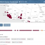
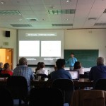
On Wednesday night the Spatial Analysis Lab hosted workshop instructor Teresa Clary to lead an 90 minute session on Ebola First Responder Mapping with OpenStreetMap. The workshop was heavily attended, pushing the SAL and its computer capacity to the limits. The Humanitarian OpenStreetMap Team has developed a project called MapGive, which encourages volunteers to help […]

Ebola First Responder Mapping Workshop

Wednesday October 8, 7:00 pm in the Spatial Analysis Lab (Sabin-Reed 104) How can you help the Red Cross, Doctors Without Borders, the World Health Organization, and others fight the Ebola epidemic in West Africa?  By attending a free workshop to learn how to edit the map data necessary to coordinate the response effort.  Once […]

Fall 2014 Workshops

The following workshops are offered by the Spatial Analysis Lab this fall.  Sign up for workshops and express interests for workshop offerings on this form – note: some workshops will only be offered on request. Introduction to Web Mapping Intermediate Web Mapping GPS (Parts I & II) Communicating Data with Maps Web Mapping with Google Products Descriptions […]

Summer GPS Workshop

What? Summer GPS Workshop Why? If you have a summer research project, internship, or job that might require you collect GPS data, sign up for the Spatial Analysis Lab GPS Workshop to learn how to use GPS units, optimize the accuracy of your GPS data, and process the data into a finished map product! We’ll […]

Spring 2014 GPS Workshops!

What? The snow has melted (mostly) … the sun is out (mostly) … the semester is winding down (OK, not at all). You know what that means? It’s time for another round of GPS workshops! Why? If you have a summer research project, internship, or job that might require you collect GPS data, sign up […]

Thursday Oct. 18: GPS & Mobile Data Collection Workshop

We’re happy to announce the first Spatial Analysis Lab workshop of the fall semester! Come to the Spatial Analysis Lab at 4pm on this Thursday, October 18, for Spatial Data Collection: From GPS to iOS. From high-tech GPS units with lasers to easy phone/tablet apps that are always in your back pocket, spatial data collection can strengthen […]

Digital Humanities Workshop Recap

On Monday and Tuesday, August 13-14, the Smith Spatial Analysis Lab teamed up with Amherst College to host a workshop for Five College faculty entitled Spatial Techniques for the Digital Humanities. We had a great two days of discussion, learning, and collaboration, as workshop participants and instructors alike worked through eight themed sessions focusing on […]

Spatial Techniques for Digital Humanities

In collaboration with Amherst College, the Spatial Analysis Lab is developing a spatially themed workshop titled “Spatial Techniques for the Digital Humanities“.  The workshop is part of the Five College Digital Humanities Initiative which promises to enrich curricula and scholarship through digital humanities projects.   The workshop also builds on previous and continued collaboration to […]