The Interterm 2017 Drone Course will offer students an opportunity to learn about drone technology with a focus on mapping and image analysis to support conversation efforts. In addition to gaining an understanding of the technology, students will learn how to fly drones safely, legally, and responsibly in the national and public airspace. The course […]
Tag Archives: Classes
February 2015 Update (16th – 27th)
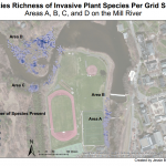
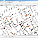
It has been a busy two weeks in the Spatial Analysis Lab. Read on to learn about our most recent support of GIS work across campus. 1. Class Support 2. Student Support 3. Faculty Support 4. Outreach 5. Campus Connections 1. Class Support We kicked off our work with Professor Camille Washington-Ottombre’s class Environmental Integration II: Collecting […]
Spring Semester Update (Jan 12 – Feb 13)
Snow or shine, the SAL is working hard this semester. See our most recent activity outlined below: 1. Class Support 2. Student Support 3. Faculty Support 4. Outreach 5. Campus Connections 1. Class Support We’ve been working with a Professor Camille Washington-Ottombre to design two new water related GIS labs for Environmental Integration II: Collecting and Analyzing Information (ENV201/202). […]
News Update: John Snow’s Map and World Populations Class
This semester has flown by– it’s hard to believe that Spring Break has already come and gone. Though much of what we do in the SAL is support classses on an ongoing basis throughout the semester (like ENV 201/202 and ARH 150), it is always fun to have the chance to work with classes for […]
News Update: October 29, 2012
With the fall semester halfway over, things have been pretty hectic in the Spatial Analysis Lab! We are gearing up to provide regular support to two additional Environmental Science and Policy classes in the coming months. Students in a core course in the major, Collecting and Analyzing Information, will be working with GIS data to […]