This semester has been one of the busiest that the SAL has seen. In total, 11 classes worked with our spatial technology at some point during this semester. We also supported student projects and worked on several of our own projects. Here are some of the highlights: ~Classes~ Lisa Armstrong’s class Gender, Land, and […]
Tag Archives: Campus
Collaboration with the Art Museum!
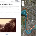
by Karen Yu, Spatial Analysis Lab Assistant Despite its physical appearance, the Spatial Analysis Lab (SAL) is more than just a computer lab in Sabin Reed. Behind the scenes, we’re often busy with new projects, teaching, and always thinking spatially. Recently, the Art Museum reached out to collaborate with the SAL on a new exhibit […]
Fall 2015 Mystery Map-Data
We have cool, shiny new LiDAR data to play with in the Spatial Analysis Lab. These data were captured in December 2013, but we did not receive the final product until earlier this summer. We’ll provide more details about LiDAR, and our plans for processing and analysis after the Mystery Map competition is complete. Until […]
Senior Week Workshops
Calling all aspiring cartographers and spatial thinkers! Interested in developing your map-making skills? Have some spare time during Senior Week? The Spatial Analysis Lab would like to invite Smith students, faculty, staff, and community to join us for a series of informal mapping workshops Tuesday – Friday of Senior Week (5/12-5/15). The workshops are open […]
April Update
See what work the Spatial Analysis Lab (SAL) supported in the busy month of April 1. Class Support 2. Student Support 3. Campus Connections 4. Outreach 1. Class Support: Environmental Integration II: Collecting and Analyzing Information (ENV201/202): Final Presentations: One of the five student groups in 201/202 decided to focus their final project on looking at […]
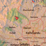
Nepal Earthquake Response Mapping Follow-up Workshop
In response to the recent earthquakes in Nepal the Humanitarian OpenStreetMap Team (HOT) has provided an online mapping platform that allows volunteers to help map the infrastructure of the areas in Nepal effected by the earthquakes. Mapping road networks and structures is critically important to help responders navigate the area to provide assistance to those in […]
Nepal Earthquake Response Workshop Well Attended in the Week Before Finals
The Humanitarian OpenStreetMap Team has developed a project called MapGive, which allows volunteers to populate maps in parts of the world where mapping resources are limited. The idea originated following the 2010 earthquake in Haiti when mapping the island’s infrastructure through GPS surveying on foot proved too dangerous and not fast enough. As an alternative OpenStreetMap provided a […]
Winter Mystery Map Revealed
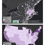
Answer Revealed: As many of you successfully guessed — our winter mystery map, themed: Annual Valley Event, was mapping… Valley Gives Day 2014! Making the Map The first map produced was the one used as the winter mystery map. […]
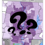
Winter 2015 Mystery Map
In celebration of the indoors we bring you our latest Mystery Map to help occupy your mind through the last of the winter’s cold! Challenge: Name the Annual Event Bonus: Explain the Pattern click to expand Submit answers here by Friday 3/6 — winner will be announced soon after
Spring Semester Update (Jan 12 – Feb 13)
Snow or shine, the SAL is working hard this semester. See our most recent activity outlined below: 1. Class Support 2. Student Support 3. Faculty Support 4. Outreach 5. Campus Connections 1. Class Support We’ve been working with a Professor Camille Washington-Ottombre to design two new water related GIS labs for Environmental Integration II: Collecting and Analyzing Information (ENV201/202). […]