Learn to create maps that affect social change with design thinking principles at the Maps that Engage and Promote Change Workshop this coming week. Please register here. On Day One: (Monday, May 14 in the Design Thinking Studio – Capen Annex) Learn about the lineages of cartography with particular emphasis on critical cartography and counter-mapping […]
Category Archives: Cartography
February 2018 Mystery Map Solution
March right in to find out what the February Mystery Map was about! While the map received more than 300 views, we had modest submissions (must be fight-or-flight response to Google Forms.) Scott Gilman, our previous post-bac fellow, promptly solved the map shortly after it was posted (22 minutes to be exact, but, there was […]
Mystery Map 2018 Kickoff
The state of affairs for a new year can be uncertain, but your unequivocal love for map mysteries is huge! [advanced_iframe securitykey=”5bc49ba0db168937774fd40d43b1f0f57eecc76d” src= “https://smithgis.carto.com/builder/8fca40dd-aad5-4a0a-b46b-e2e4f507ab8a/embed”] You can launch the full version here. Hint: Not sports-related despite the title, but a clue is embedded in the post. [advanced_iframe securitykey=”5bc49ba0db168937774fd40d43b1f0f57eecc76d” src=”https://docs.google.com/forms/d/e/1FAIpQLSfzE8R5iftl5ihZyff1Z2tk5ihT1epSnhfYXajXkakCfZKVxg/viewform?embedded=true” width=”760″ height=”500″ frameborder=”0″ marginheight=”0″ marginwidth=”0″]
Today in History as Told by Maps: September 19, 1987 / Fictional Maps
A cult classic, The Princess Bride first captured the hearts and minds of viewers on this day in 1897 (starting, of course, with the Grandson.) The story followed a slew of characters as they traversed the inconceivable landscapes of Florin and Guilder. The love-revenge-espionage plot cast the characters in a wild game of cat and […]
First Mystery Map of the 2017-2018 Academic Year
What better way to kick off the fall semester with a Mystery Map? The stakes are high–pride and glory, a spot on the Mystery Map Hall of Fame™, and negotiable baked goods. Behold: When you have a guess, submit your answers below. Submissions are accepted until the end of September!
Today in History as Told by Maps: September 12, 1229
James I of Aragon (appropriately known as James the Conqueror) landed at Santa Ponça, Majorca on this day in 1229—launching the first of his campaigns to capture the Balearic Islands. The largest of the islands, Majorca lies at the heart of economic and cultural interchanges in the Mediterranean. Its geographic location made it highly coveted […]
Cartography Across Disciplines: Archaeology in the SAL
By SAL Assistant Rachel Moskowitz ’18 During the fall semester, Professor Liz Klarich came to the Spatial Analysis Lab to ask for assistance with a series of maps for her book manuscript. She requested help with three publication maps detailing her archaeology research in Pukara (Pucará), near Lake Titicaca in the Peruvian Andes. Professor Klarich […]
Bringing back hand-drawn maps (or, how to be a hipster cartographer)
Two weeks ago, I attended the annual conference of the North American Cartographic Information Society (NACIS) in Colorado Springs as part of our ongoing efforts to integrate design thinking into how we teach cartography at Smith. Attendees come from all corners of the cartography world: from illustrators of fictional maps to developers of map-based mobile applications. As […]
Senior Week Workshops
Calling all aspiring cartographers and spatial thinkers! Interested in developing your map-making skills? Have some spare time during Senior Week? The Spatial Analysis Lab would like to invite Smith students, faculty, staff, and community to join us for a series of informal mapping workshops Tuesday – Friday of Senior Week (5/12-5/15). The workshops are open […]
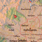
Nepal Earthquake Response Workshop Well Attended in the Week Before Finals
The Humanitarian OpenStreetMap Team has developed a project called MapGive, which allows volunteers to populate maps in parts of the world where mapping resources are limited. The idea originated following the 2010 earthquake in Haiti when mapping the island’s infrastructure through GPS surveying on foot proved too dangerous and not fast enough. As an alternative OpenStreetMap provided a […]