By Kalynn Kosyka, Computer Science & Data Science ’19 Currently, Smith College is going through major renovations which resulted in many staff members being relocated. The Campus Directory Map will allow the user to query on name, department, and/or person type (faculty, staff, student) from the college directory. After querying, the user will be directed […]
Category Archives: Data
New Elf on the Block – Experience Using Bad Elf GPS With and Without Differential Correction
By Sofia Johnson ’19 As part of our work in the Spatial Analysis Lab, we like to check the accuracy of our equipment by testing it ourselves. We have the opportunity to use new and interesting technology such as new GPS equipment, but we want to assure the quality of our results. Thus, we tested […]
November Mystery Map Revealed — Mystery Migrations
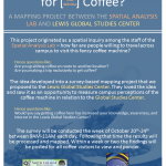
Answer Revealed This mystery map challenged viewers to anticipate movements on campus based on a set of starting points and ending points. What quest is shown on the map?? The journey to the Lewis Global Studies coffee machine! The map was inspired by a mapping survey conducted at this coffee machine in Wright Hall. The survey gathered […]
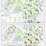
Coffee Mapping Project Results
The results from the coffee mapping project are in! Click here to visit the online interactive map application Click here to view compiled maps in PDF form The results contain maps like: Line Density of Travel including Coffee Machine Specific Visits to Coffee Machine Combined Visits — organized by campus affiliation Combined Visits — colored […]
Mapping Smith Coffee Migration Patterns
On the Smith campus lives a secret coffee machine that dispenses wonderful lattes and cappuccinos at no cost to its users. **For the sake of protecting the machine’s identity we will not explicitly state its location or hours of operation in this article. This magical coffee machine is a common topic of conversation in Sabin-Reed — […]
Last Week Review (October 13th-17th)
Participations from the SAL during the week of October 13th-17th: 1. Lying with Maps: initial lab session with ENV311 2. Meeting with Lewis Global Studies Center about Study Abroad data 3. Ebola Mapping Workshop at Amherst College 4. Finalized India Rainfall Maps with Economics Professor Vis Taraz 5. One-on-one sessions with “mappers” from Study of […]
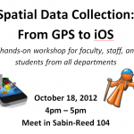
Thursday Oct. 18: GPS & Mobile Data Collection Workshop
We’re happy to announce the first Spatial Analysis Lab workshop of the fall semester! Come to the Spatial Analysis Lab at 4pm on this Thursday, October 18, for Spatial Data Collection: From GPS to iOS. From high-tech GPS units with lasers to easy phone/tablet apps that are always in your back pocket, spatial data collection can strengthen […]
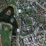
Google Earth Imagery Updates and Curiosities
I just noticed a Google Earth imagery update for the Smith College campus area. Great new imagery and quite different from the springtime orthophotography I usually work with. These images are full of plump tree canopies and appear to be taken during the summer. Closer inspections indicates the imagery is of a 09/18/2011 vintage. As […]
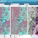
Landsat Imagery Services
These image services enable fast and easy access to 30 years of Landsat imagery as part of ArcGIS Online.
All Orthophotos Available on GEO
The latest Orthophotos (2008-2009) are now available locally on GEO. You may now load the images from: Q:dataimages2008-2009Orthophotos or gishomedataimages2008-2009Orthophotos Remember, it is much easier to load and use the orthophoto images with image or raster catalogs. Two raster catalogs are available: IMGCAT_COQ2008_2009SID_30CM.dbf {for 30 cm images} and IMGCAT_COQ2008_2009SID_15CM.dbf {for 15cm images in select […]