Besides just an understanding of how to make maps, we hope that students leave the SAL with an appreciation for the power inherent in making and presenting maps. An exhibit currently on display in the Knowledge Lab called Undesign the Redline highlights a particular set of maps known as Redlining Maps which have powerfully shaped […]
Category Archives: Digitial Humanities
Update: When In Rome
Our most loyal readers may remember that we announced a collaborative project with the Smith College Museum of Art back in March. We set off last semester to create a Story Map for their autumn exhibition, When In Rome: Prints & Photographs, 1550-1900. In addition to serving as a public, digital archive of the exhibition, […]
Summer science classes in the SAL
For four weeks during July and August, the SAL was abuzz with activity as dozens of high-school students designed web maps on topics ranging from local geology to bird migrations in East Asia. We worked with three different classes in the high school summer programs this year: Anne Wibiralske’s Field Studies in Sustainability class, Ethan […]
Collaboration with the Art Museum!
by Karen Yu, Spatial Analysis Lab Assistant Despite its physical appearance, the Spatial Analysis Lab (SAL) is more than just a computer lab in Sabin Reed. Behind the scenes, we’re often busy with new projects, teaching, and always thinking spatially. Recently, the Art Museum reached out to collaborate with the SAL on a new exhibit […]
Drones in the Humanities
Five College Digital Humanities Grant As an emergent technology, it is perhaps not surprising that there is not a clear consensus on what a drone is. Even what constitutes the technology of a drone—or, more accurately for the purposes of this grant, a civilian drone—is up for interrogation. Under FAA regulations, model airplanes, weather balloons, […]
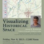
Visualizing Historical Space
Great opportunity to learn about Historical GIS (HGIS) from one of the leading thinkers in the field. Anne Knowles from Middlebury College will be on campus this Friday, November 8th to discuss her work on visualizing the Battle of Gettysburg. Explore the online map for a little preview: A Cutting Edge Second Look at the Battle […]
Digital Humanities Workshop Recap
On Monday and Tuesday, August 13-14, the Smith Spatial Analysis Lab teamed up with Amherst College to host a workshop for Five College faculty entitled Spatial Techniques for the Digital Humanities. We had a great two days of discussion, learning, and collaboration, as workshop participants and instructors alike worked through eight themed sessions focusing on […]
Spatial Techniques for Digital Humanities
In collaboration with Amherst College, the Spatial Analysis Lab is developing a spatially themed workshop titled “Spatial Techniques for the Digital Humanities“. The workshop is part of the Five College Digital Humanities Initiative which promises to enrich curricula and scholarship through digital humanities projects. The workshop also builds on previous and continued collaboration to […]