

Each May, the Northeast Arc Users Group (NEArc) hosts a GIS conference at UMass for GIS professionals, researchers using GIS, and geography enthusiasts. The conference is a great way to see the many ways that others are using GIS across New England. There are also workshops to learn cutting-edge GIS skills and many opportunities to […]
Spatial Thinking at Undesign the Redline
Besides just an understanding of how to make maps, we hope that students leave the SAL with an appreciation for the power inherent in making and presenting maps. An exhibit currently on display in the Knowledge Lab called Undesign the Redline highlights a particular set of maps known as Redlining Maps which have powerfully shaped […]
Interterm GIS
With 17 students, including Smithies, Five College students, and community members, this year’s interterm GIS class was one of the largest we can remember. After modeling a flood scenario in Florence and discussing the nature of GIS data, the students were the first to test the blended learning module on cartographic design that we’ve been […]
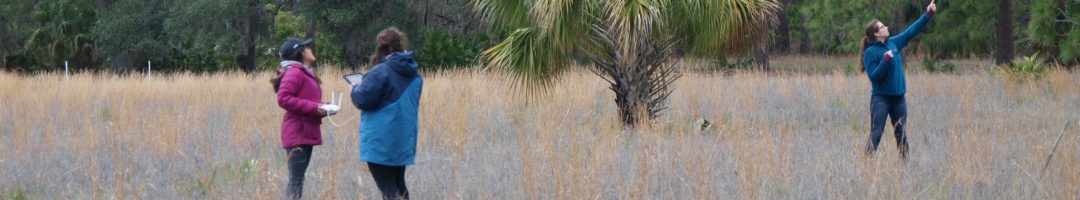
Fly-Day the 13th: The Conclusion of “Fun with Drones”
This post was authored by Alex Widstrand ’17, co-instructor of the SAL’s interterm drone course “Fun with Drones”. It originally appeared on the Drone Thinking Initiative blog on January 14th. As this week comes to a close, we marked Friday, 1/13, as the final day of our first interterm drone course here at Smith. We […]
Wrapping Up Fall 2016
This semester has been one of the busiest that the SAL has seen. In total, 11 classes worked with our spatial technology at some point during this semester. We also supported student projects and worked on several of our own projects. Here are some of the highlights: ~Classes~ Lisa Armstrong’s class Gender, Land, and […]
Diversity on Diversity
Although embedded deeply within the Sciences at Smith, the Spatial Analysis Lab routinely crosses boundaries to work in other domains. One recurring theme is mapping justice and the typical focus is environmental justice given our grounding. But more recently our attention is drawn to issues involving social/economic justice and inequality. Much of our work in […]
Tofurkey Map Wrap-up
Thanks to all of you who participated in this year’s Tofurkey Map! 259 Smithies contributed their Thanksgiving break destination to the map. Here’s a few fast facts compiled by SAL Assistant Ellen Sulser ’18: Most popular dishes: (1) Stuffing – 42 respondents; (2) Mashed potatoes – 34 respondents; (3) TIE: Pumpkin pie and Turkey (34 respondents each) […]
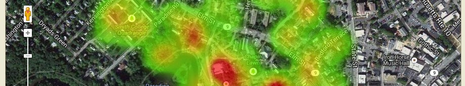
Post-election Media Monitoring + Mapathon
This Monday, 11/21, the Spatial Analysis Lab is hosting a Media Monitoring + Mapathon event to support a crowd-sourced map of post-election harassment incidents across the country. Volunteers will look through reports of harassment incidents in traditional media and public social media sources, locate the events on a map, and fill out a form of information […]
Third Annual Tofurkey Map
Are you flying across the world for Thanksgiving break? Or maybe you’re not planning to leave your dorm for five days? In either case, we hope that you’ll contribute to this year’s Tofurkey Map, a tradition started by former Post-Bac Fellow Victoria to document where and how Smithies are spending the holiday!
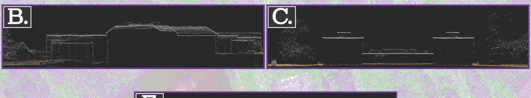
Drone Course – January 2017
The Interterm 2017 Drone Course will offer students an opportunity to learn about drone technology with a focus on mapping and image analysis to support conversation efforts. In addition to gaining an understanding of the technology, students will learn how to fly drones safely, legally, and responsibly in the national and public airspace. The course […]