

Two weeks ago, I attended the annual conference of the North American Cartographic Information Society (NACIS) in Colorado Springs as part of our ongoing efforts to integrate design thinking into how we teach cartography at Smith. Attendees come from all corners of the cartography world: from illustrators of fictional maps to developers of map-based mobile applications. As […]
October Mystery Map Solution
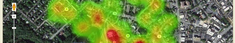
Only one person submitted a guess to our latest Mystery Map competition. Amazingly enough, this guess was correct for all three variables, so congratulations – again – to Sam Masinter! Here are the winning answers: Variable A: number of scientific* Nobel Prizes per country Variable B: number of universities per country (see this link for […]
First Mystery Map of the Year!
We’re excited to release the first Mystery Map of the 2016-17 academic year! We had plans to create one much earlier in the year, but we’ve been so busy that it feels like we blinked on Labor Day and woke up in mid-October. Check out the map by clicking on the image below. When you […]
Update: When In Rome
Our most loyal readers may remember that we announced a collaborative project with the Smith College Museum of Art back in March. We set off last semester to create a Story Map for their autumn exhibition, When In Rome: Prints & Photographs, 1550-1900. In addition to serving as a public, digital archive of the exhibition, […]
Upcoming Projects in the SAL
In addition to our regular workshops and the ten classes we plan to work with this semester, the SAL staff have some exciting projects on the plate for this fall! Drones Back in June, the FAA announced new regulations on drone flying that went into effect on August 29. The new rules make it much easier for […]
Summer science classes in the SAL
For four weeks during July and August, the SAL was abuzz with activity as dozens of high-school students designed web maps on topics ranging from local geology to bird migrations in East Asia. We worked with three different classes in the high school summer programs this year: Anne Wibiralske’s Field Studies in Sustainability class, Ethan […]
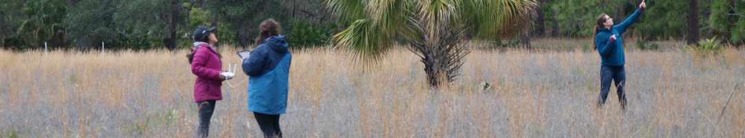
Droning in Belize
Back in June, I had the pleasure of spending a week in San Pedro, Ambergris Caye, Belize, assisting the Coral Reef Edventures program, known as Coral Ed for short, with their marine ecology research. For the past 14 years, adventurous Smith students interested in marine science and education (among other topics) have ventured to Belize […]
Wrapping up Web GIS at UMass
Throughout this semester, we’ve been working with a Five College class at UMass called “Community Service with Web-Based Geographic Information Science and Technology (GIST)” that Jon was co-teaching. The five Smith students in the class worked on two semester-long projects for their community partners. We encountered many bumps along the way, but despite it all […]
Flying Drones in Popham Beach
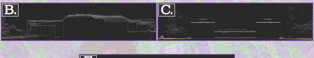
Two weeks ago, the SAL team headed to Popham Beach State Park, Maine, with Prof. Bob Newton’s Geomorphology class. Bob has taken his Geomorphology class there for several years to assess erosion at the beach. A major erosion event in the mid 2000s threatened the park’s facilities and nearby homes, which were previously shielded from […]
May Mystery Map Wrap-up
After a series of mystery maps that were cracked within a day, it looks like we finally stumped you! Believe it or not, nobody solved our most recent Mystery Map. We had some good guesses: several people guessed it was simply distance from Northampton in miles. This is on the right track, as it offers a plausible […]