

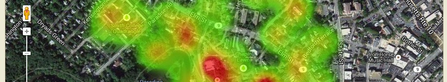


Which do you think is more effective? The “official” announcement shown below or a shiny new map? Maybe both? Official Announcement -> Notice of construction activity from Facilities Management Park House: On Tuesday, May 26, the contractor will be setting up construction fencing around Park House and the one-way drive behind Park House will be […]

Geography Lesson for Legislators
Illustrating those same data on a map, which ironically, had not been done before, demonstrated the inequities of the proposals and actually helped generate better funding for the disadvantaged districts.
Intellectual Inquiry 2006
In the summer of 2006, the Spatial Analysis Lab participated in a pre-orientation program titled “Intellectual Inquiry” Files Google Earth File (kmz) showing painting and artist’s approximate location from the Northampton Dome. Google Earth File (kmz) showing 1831 Map of Northampton, published by Pendleton’s Lithography, Boston, MA
Image Tip for ArcGIS
Did you know that you can “drag and drop” images from Windows Explorer onto ArcMap? You can! No more waiting for ArcCatalog to load the images into the contents panel. Save time and browse with Windows Explorer to your image collections (e.g. 2005 Orthophotos).
Who moved my GIS?
ESRI is readying the release of ArcGIS 9.2 and there will undoubtedly be changes that affect how you work and / or how your GIS exercises hold up to the rigors of student use. I’ll organize a 9.2 “debriefing” mid to late August when I return from the ESRI User Conference. In the meantime, take […]
New – 2005 – Orthophotos are available
he 2005 Massachusetts Orthophotos are now available for Western Massachusetts. Visit the MassGIS webstie for details. All orthophotos are available in the SAL on GEO. Just connect to: Geodatavolgisdataus_stateseastusamaImagesOrthophotos2005 and start viewing gorgeous imagery.
15 minute USGS maps
We now have historic 15 minute USGS maps for Massachusetts in our Special Collections data library. These maps were acquired from the Harvard GeoSpatial Library which is a great resource for mappers and historians alike. You can now access these maps “locally” from our server – geogisdataspecial_collectionsma_15min_quads Enjoy….
Digital USGS Topographic map sheets for entire US available
tarting in January, 2006, you will have access to all USGS topographic map sheets from within ArcGIS. National Geographic’s TOPO! Professional Suite for ArcGIS will be installed in the Spatial Analysis Lab during Interterm. Instructions and demonstrations will be scheduled soon. Special thanks to the Library (especially, the Science Library) for purchasing the software and […]