

From Pilgrims to Pluralism: America’s Religious Landscape, by Lydia Rainville ’07
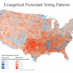
From Pilgrims to Pluralism: America’s Religious Landscape, by Lydia Rainville ’07
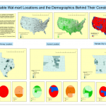
Katherine Jones Geo150, spring 2007 Wal-Mart Stores Inc. has grown in the last forty years to be one of the most successful retailers in the world. In 2007 the company reported having 1,063 regular stores and 2,285 Supercenters in the United States alone1. This success, however, has been subject to great controversy. The retailer has […]
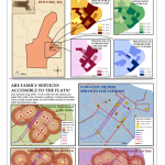
María J. Rendón GEO150, spring 2007 THE RECOVERY OF HOLYOKE THROUGH FAMILY-ORIENTED SERVICES Holyoke is notoriously known to be the poorest city in the state of Massachusetts. Its high poverty levels are intrinsically tied to a variety of problems among the youth, such as high drop-out rates, crime and substance abuse, teenage pregnancy, etc. In […]
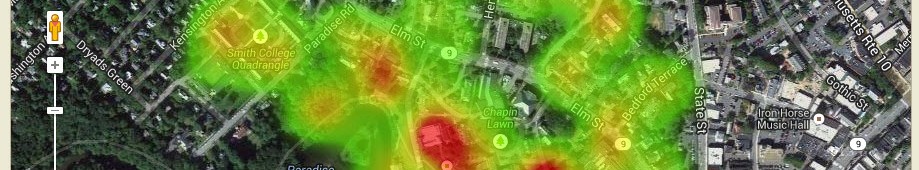
Take a look a sneak preview of the 2009 Orthophotography courtesy of MassGIS, Commonwealth of Massachusetts Executive Office of Environmental Affairs and a buddy of mine at PVRPC. In the Google Maps overlay, check out: — * the kayakers on Paradise Pond * Nat Fortune’s “house” on Burton Lawn * blankets and students on Chapin […]
Download the Google Earth file and explore: Spatial Mean (kmz)
Simple changes in data classification alter the patterns and display of a map. Examples of mapping 1990 US Population Density.
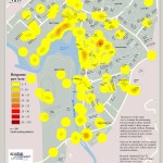
View as Google Earth File In the BIO110 seminar, Pests, Plagues, and Profligates: The Biology of Invasions students interact and explore John Snow’s London Cholera, 1854 data. They can do their own analysis, explore distance, proximity, and density among other metrics.
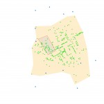
The purpose of this study was to examine the relationship between Smith College students and the Smith College campus through a spatial medium
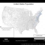
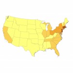
Animating Spread of European Settlement in the US 1790-2000
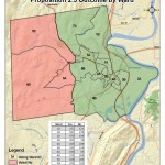
Mapping the comfortable margin of the Northampton Proposition 2 1/2 override tells a different story…