October Mystery Map Solved!

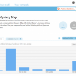
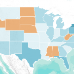
October Mystery Map: “Fifty Nifty United States” What do the eleven orange states have in common? The answer is: There are no students in the Smith College Class of 2016 from any of the orange states (Alabama, Delaware, Hawaii, Idaho, Mississippi, North Dakota, Nebraska, Nevada, South Dakota, West Virginia, and Wyoming). The map below shows […]

October Mystery Map

October Mystery Map: “Fifty Nifty United States” What do the eleven orange states have in common? In elementary school, we learned that there are “fifty nifty United States” … but some of these states are not like the others! Use your map-reading and critical thinking skills to figure out what this map shows. Check out […]

Using GIS to Investigate the Ecological Effects of Urban Sprawl

Smith students and faculty who are interested in Environmental Science and Policy, Geoscience, or Ecology should check out this week’s Sigma Xi talk on using GIS to investigate the ecological effects of urban sprawl! Cory Keeler, the Spatial Analysis Lab post-bac fellow, will be speaking about the role of spatial analysis in identifying areas where […]

September 2012 Mystery Map Solved

The September 2012 Mystery Map depicts monetary contributions to the candidates in the Massachusetts 2012 senate race, Scott Brown and Elizabeth Warren.

Digital Humanities Workshop Recap

On Monday and Tuesday, August 13-14, the Smith Spatial Analysis Lab teamed up with Amherst College to host a workshop for Five College faculty entitled Spatial Techniques for the Digital Humanities. We had a great two days of discussion, learning, and collaboration, as workshop participants and instructors alike worked through eight themed sessions focusing on […]

Spatial Techniques for Digital Humanities

In collaboration with Amherst College, the Spatial Analysis Lab is developing a spatially themed workshop titled “Spatial Techniques for the Digital Humanities“.  The workshop is part of the Five College Digital Humanities Initiative which promises to enrich curricula and scholarship through digital humanities projects.   The workshop also builds on previous and continued collaboration to […]

April 2012 Mystery Map Solved

The Answer is The April 2012 Mystery Map reveals monetary contributions to David Narkewicz and Michael Bardsley during the 2011 Northampton Mayoral Campaign.  The points are located at the contributor’s address and sized proportionally to indicate the amount of contribution.  Each point is color coded by candidate: Narkewicz is light green,  Bardsley darker green. And, the winner […]

Spatial Perspectives: A Podcast Series

NITLE begins a new podcast series entitled Spatial Perspectives.  The first installment begins with Sean Connin, Program Officer for Science and Technology at NITLE, asking Jon Caris, GIS Specialist at Smith, a few questions on cross-curricular uses of GIS.

Women and Navigation Skills

These findings show that women perform better and more readily adopt search strategies appropriate to a gathering lifestyle than men

Illustrating the Invisible

The purpose of this study was to examine the relationship between Smith College students and the Smith College campus through a spatial medium