Northridge Earthquake

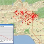
This example demonstrates display of space and time events.  Data were developed and animated in ESRI’s ArcGIS software and exported to a QuickTime movie format. Northridge Animation (Quicktime Movie showing number of aftershocks by time and location)               Originally developed for a textbook on GIS and Natural Disasters.

Intellectual Inquiry 2006

In the summer of 2006, the Spatial Analysis Lab participated in a pre-orientation program titled “Intellectual Inquiry” Files Google Earth File (kmz) showing painting and artist’s approximate location from the Northampton Dome. Google Earth File (kmz) showing 1831 Map of Northampton, published by Pendleton’s Lithography, Boston, MA