Winter 2015 Mystery Map

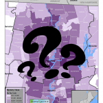
In celebration of the indoors we bring you our latest Mystery Map to help occupy your mind through the last of the winter’s cold! Challenge: Name the Annual Event Bonus: Explain the Pattern click to expand Submit answers here by Friday 3/6 — winner will be announced soon after

Spring Semester Update (Jan 12 – Feb 13)

Snow or shine, the SAL is working hard this semester. See our most recent activity outlined below: 1. Class Support 2. Student Support 3. Faculty Support 4. Outreach 5. Campus Connections 1. Class Support We’ve been working with a Professor Camille Washington-Ottombre to design two new water related GIS labs for Environmental Integration II: Collecting and Analyzing Information (ENV201/202). […]

November in Review

Well, November was quite a busy month. So busy,  in fact,  that we were unable to spend time writing weekly updates to post. Our review covers the entire month of November and is organized by type of work: Overview Class Support 1. Study of Women and Gender 230 2. Spaces of Mexico (SoMec) 3. ENV201/202 4. Soc232 Student […]

Last week in Review (October 27-31)

Recap: ENV 201 GIS Lab 1 ENV 311 Lying with Maps Lab Bird Window Collision Mapping Project Halloween in the SAL Details: ENV 201 GIS Lab 1 EVN201/202 met in the Spatial Analysis Lab for its second mapping session of the semester. This time we explored vector data with tools like Field Calculator, Buffer, and […]

Last Week Review (10/20-10/24)

Happy Fall! The highlights from last week’s work in the SAL are as follows: 1. GPS Lab with Professor Ninian Stein’s ENV 201/202 2. Ebola First Responder Social Mapping Night 3. Zebra Fish project continues 4. Coffee machine mapping survey conducted 5. Continued SWG 230 individual meetings 6. Digitizing Coral Reef Mounds 1. GPS Lab […]

Last Week Review (October 13th-17th)

Participations from the SAL during the week of October 13th-17th: 1. Lying with Maps: initial lab session with ENV311 2. Meeting with Lewis Global Studies Center about Study Abroad data 3. Ebola Mapping Workshop at Amherst College 4. Finalized India Rainfall Maps with Economics Professor Vis Taraz 5. One-on-one sessions with “mappers” from Study of […]

Last Week in Review (10/5 – 10/10)

The highlights of last week’s work in the Spatial Analysis Lab, with additional details provided below: –          Meeting with Margaret Bruzelius and STRIDE students –          Zebra Fish project updates –          Omeka and Scalar research –          OpenStreetMap Workshop for Ebola Relief Workers –          Data Science guest lecturing Margaret Bruzelius and STRIDE students: […]

Ebola Mapping Workshop Packs Room

On Wednesday night the Spatial Analysis Lab hosted workshop instructor Teresa Clary to lead an 90 minute session on Ebola First Responder Mapping with OpenStreetMap. The workshop was heavily attended, pushing the SAL and its computer capacity to the limits. The Humanitarian OpenStreetMap Team has developed a project called MapGive, which encourages volunteers to help […]

Last Week in Review (9/29 – 10/3):

Last week kicked off with the celebration of historic Mountain Day. While the students ventured into the mountains and apple orchards, the Spatial Analysis Lab was processing GPS data collected by Professor Amy Rhodes and Alanna Sparagna, a senior student who sacrificed her final Mountain Day to be in the Lab. Project details here.  We […]

Four Weeks In

Four Weeks In: So much Accomplished, but OH So Much More to Do The fall semester is in full swing, and the Spatial Analysis Lab (SAL) is feeling the heat of the ever quickening pace across campus. The month of September has been packed full of workshops, class support, individual faculty and student support, new […]