Digital Dirt – Managing Botanic Garden Data

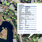
The Spatial Analysis Lab is working with the Smith College Botanic Garden to develop an open and robust data model based on the fine work by the Alliance for Public Gardens GIS (APGG).   This effort began as a tiny seed almost 10 years ago, but languished without light and nourishment.  Now, conditions seem ripe to […]

Top 5 Skills Needed to be Successful in a GIS Career – free Webinar

Learn the top 5 skills needed to be successful in a GIS career in American Sentinel University’s free Webinar, ‘Top Five Skills You Need to be Successful in a GIS Career’ on September 27 at 1p.m. EDT featuring Dr. Kerski, education manager for Esri and Dr. Devon Cancilla, Dean of business and technology for American […]

Student Assistant Positions in the SAL

Exciting and Challenging student positions in the Spatial Analysis Lab are now posted and open for applications.  Please visit the JobX website and look for the following positions (hint: search for “spatial”) Mapper Girl Mapper girl is the lead super hero and the position is part of the On Campus Internship Program (OCIP). GeoEvent Girl […]

GIS and Community Health Planning Conference

Papers presented at the University at Albany School of Public Health 7th annual GIS and Public Health conference are now available and include: “All Public Health is Local” : The Community Perspective on GIS and Public Health Russell Kirby, University of South Florida Creating Community Health Indicators Using Spatial Smoothing, Aggregation and Masking Thomas Talbot, […]

NYC Housing and Neighborhood Survey – GIS Intern

The NYC Housing and Neighborhood Survey is an experimental study of 3,000 households randomly assigned to receive in-place subsidized housing in one of eleven large-scale new construction rental developments sponsored by the City of New York’s Department of Housing Preservation and Development (HPD). The proposed project will provide an in-depth examination of the association between […]

Wildlife Population Ecologist

Mass DEP is looking for a Wildlife Population Ecologist. The applicant must have strong analytical capabilities relative to population dynamics modeling using statistical models, remote sensing, GPS and GIS applications in the conservation and management of vertebrate species. Primary focus is on the design and production of landscape-level analyses and map products. The position is […]

Landsat Imagery Services

These image services enable fast and easy access to 30 years of Landsat imagery as part of ArcGIS Online.

Spartina Control Monitor Internship

…identification of native and invasive Spartina species and their hybrids, and in the use of ArcPad software on Trimble GPS units to relocate previously-mapped invasive Spartina patches and to record treatment of these patches during treatment activities.

Food Bank Mapping

The Food Bank of Western Massachusetts sought mapping and analysis support from the Spatial Analysis Lab during the summer of 2010.  The project is currently on hold, but you can view some of the initial map products below.  Sarah Motti ’10 provided assistance on the project during her summer employment in the SAL. In many […]