Go Fly a Kite

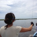
I now have a good answer to that common question – “What did you do on Summer Vacation”?  The answer is “I flew kites in Belize”.  A fun answer, but this was no vacation.   It was actually quite a bit of work, but our efforts at capturing aerial imagery from a kite platform worked […]

April 2012 Mystery Map Solved

The Answer is The April 2012 Mystery Map reveals monetary contributions to David Narkewicz and Michael Bardsley during the 2011 Northampton Mayoral Campaign.  The points are located at the contributor’s address and sized proportionally to indicate the amount of contribution.  Each point is color coded by candidate: Narkewicz is light green,  Bardsley darker green. And, the winner […]

April 2012 Mystery Map

A new Mystery Map is in the wild!  Let the thinking and voting begin. Note – anyone may participate and vote, but only members of the Smith College community may claim a prize.         Update / Hint:  The mystery points are primarily associated with Northampton, MA, although you do see points in the […]

Spring NEARC 2012

Smith College once again hosts the “Biggest Little Most Reasonably Priced GIS (BLRPGIS) Conference in New England”.  Abstracts are in and planning is well under way as we prepare to host our 9th annual spring NEARC (Northeast ArcInfo Users Group) Conference.  We are still accepting poster entries. The preliminary schedule is now available.  Some highlights include: Updates from […]

NATIONAL GEOGRAPHIC AWARD IN MAPPING

Undergraduate students and master’s-degree candidates are invited to apply for the National Geographic Award in Mapping. This award recognizes student achievement in the art, science, and technology of mapping and seeks to encourage student research. The first place award consists of a cash prize of $900 (U.S.) and the second place award is $300 (U.S.). […]

ESRI Virtual Campus Updates

Listed below are some of the updated ESRI Virtual Campus Courses that cover ArcGIS 10. Newer Virtual Campus Web Courses Timeline 3D Analysis of Surfaces and Features Using ArcGIS 10 3 hours 3D Visualization Techniques Using ArcGIS 10 3 hours Basics of Geographic Coordinate Systems (for ArcGIS 10) 3 hours Basics of Python (for ArcGIS […]

Finding GIS Careers

Jobs and careers eventually become the focus for many our our students.  I have let slip every now and then that GIS could be thought of as a “Guaranteed Income Source”.  So,  I usually scan the GIS job boards, listerservs, etc. every now and then to get a sense of what industry and organizations are […]

Google Earth Imagery Updates and Curiosities

I just noticed a Google Earth imagery update for the Smith College campus area.  Great new imagery and quite different from the springtime orthophotography I usually work with.  These images are full of plump tree canopies and appear to be taken during the summer.  Closer inspections indicates the imagery is of a  09/18/2011 vintage.  As […]