Smith students – Help investigate whether prisons are affecting democracy in rural counties across the U.S. by reverse engineering census maps since some counties don’t remember if they used the census prison counts in their districts! Contact me to learn more.
Author Archive: jcaris

Women and Navigation Skills
These findings show that women perform better and more readily adopt search strategies appropriate to a gathering lifestyle than men
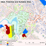
Alternative Locations for Ford Hall and Future Campus Expansion
Shu Liu Geo150, spring 2007 Smith College’s Ford Hall is an approximately 140,000-square-foot building that will accommodate its expanding Picker Engineering Program, computer science, chemistry, biochemistry, and molecular biology departments. Named in honor of the Ford Motor Company Fund, the primary donor to the scheme, Ford Hall will be a sustainable, environmentally friendly and academically-inspiring […]
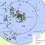
Implications of Proposed Employee Parking Cash Out Program at Smith
Melissa Kelley Geo150, spring 2007 My map displays the relationship between employee groups at Smith College (faculty, administration, administrative support, course support and service) and place of residence. In particular, my project explores the implications of the proposed employee parking cash out program, included in the new parking master plan released February 8, 2007, under […]
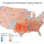
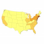
From Pilgrims to Pluralism: America’s Religious Landscape
From Pilgrims to Pluralism: America’s Religious Landscape, by Lydia Rainville ’07
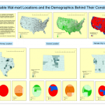
Sustainable Wal-Mart Locations and the Demographics Behind Their Construction
Katherine Jones Geo150, spring 2007 Wal-Mart Stores Inc. has grown in the last forty years to be one of the most successful retailers in the world. In 2007 the company reported having 1,063 regular stores and 2,285 Supercenters in the United States alone1. This success, however, has been subject to great controversy. The retailer has […]
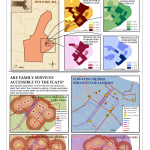
Accessibility of Family Services in the Flats of Holyoke, MA
María J. Rendón GEO150, spring 2007 THE RECOVERY OF HOLYOKE THROUGH FAMILY-ORIENTED SERVICES Holyoke is notoriously known to be the poorest city in the state of Massachusetts. Its high poverty levels are intrinsically tied to a variety of problems among the youth, such as high drop-out rates, crime and substance abuse, teenage pregnancy, etc. In […]
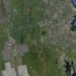
2009 Orthophotography
Take a look a sneak preview of the 2009 Orthophotography courtesy of MassGIS, Commonwealth of Massachusetts Executive Office of Environmental Affairs and a buddy of mine at PVRPC. In the Google Maps overlay, check out: — * the kayakers on Paradise Pond * Nat Fortune’s “house” on Burton Lawn * blankets and students on Chapin […]
Smith Alumnae
Download the Google Earth file and explore: Spatial Mean (kmz)
Data Classification
Simple changes in data classification alter the patterns and display of a map. Examples of mapping 1990 US Population Density.