The Cleft Segment of the southern Juan de Fuca Ridge (JdFR) is a highly symmetrical intermediate-rate spreading center (~6 cm/yr full rate) with a well-defined axial valley cut by the 30-90 m wide, 10-15 m deep, “cleft” that extends ~10 km along the center of the axial valley in the southern portion of the segment (Fig. 1.01 and Fig. 1.03) (Normark et al., 1986, 1987, Stakes and others, 2006).
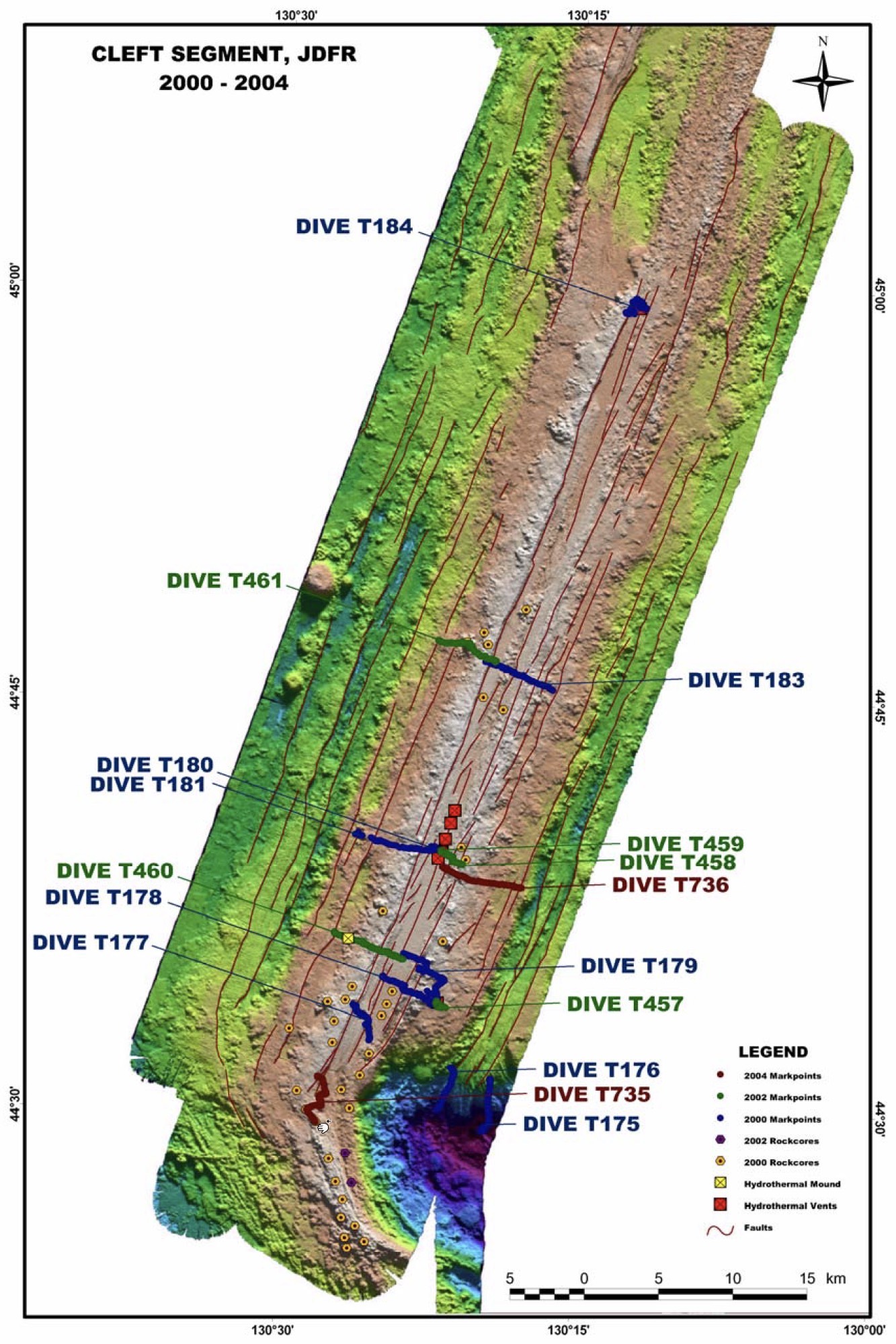
Figure 1.03. Bathymetric map of the Cleft Segment of the Juan de Fuca Ridge. Locations of ROV dives made between 2000 and 2004 are shown along with sample locations and other relevant features (after Stakes and others, 2006, Figure 1). Click on the image to see a larger version with more information.
The central “cleft” is morphologically (and perhaps genetically) identical to the axial summit collapse trough (ASCT) described for the magmatically robust East Pacific Rise (EPR) [Fornari et al., 1998]. Similar to the fast-spreading, magmatically robust northern EPR, recent volcanism and active high-temperature hydrothermal sites are concentrated in a narrow
< 100m wide zone around the “cleft” [Normark et al., 1983; 1986; 1987; Embley et al., 1991; Embley and Chadwick, 1994; Perfit and Chadwick, 1998]. The cleft is known to have been volcanically active over the past several decades, and has recently erupted lobate, sheet and massive flows (Fig. 1.01) [Normark et al., 1987, Embley et. al., 1991, Embley and Chadwick, 1994]. North and south of the area with a central “cleft”, the axial morphology changes to a more subdued axial valley dominated by thick, linear, pillow mounds; features similar to the axial volcanic ridges (AVR) common on slow spreading ridges [Chadwick and Embley, 1994; Smith et al., 1999; Head et al., 1996]. The volcanically and hydrothermally active axial valley is similar, although not identical to, the axial rift valleys or graben of slow spreading centers. The axial valley is bounded by 75-200 meter high “bow-form” ridges, postulated as vestiges of split, axial volcanoes (Fig. 1.01) [Kappel and Ryan, 1986]. These “split ridges” are suggested to delineate periods of robust axial volcanism followed by periods of tectonic extension. Thus, according to the split volcano hypothesis most of the magmatism at the Cleft Segment occurs at the axis, with cyclic oscillations between robust volcano building and waning periods of largely amagmatic faulting, extension and disruption (Smith and others, 1994).