The SAL offered two courses during interterm: Introduction to GIS and Drone Thinking.
Introduction to GIS
As foretold by a fortune cookie, “the great aim of education is not knowledge but action…with GIS” — this year’s GIS class emphasized the pedagogical shift to how to learn GIS rather than teach GIS. The materials covered in this week-long course spanned from perspectives in spatial thinking, acquiring and creating data, cartography, and solving problems with spatial analysis.
Highlights from our lab activities include:
- Learning techniques to generate spatial data such as geocoding addresses, georeferencing historical maps, and digitizing features
- Creating choropleth maps illustrating the opioid epidemic in Massachusetts, where students leverage their maps to answer one of the two questions: 1. Do road networks have an impact on the severity, or magnitude of the epidemic? 2. Is the epidemic primarily a rural issue? The map products prompted informative conversations in data classification schemes, choices in visualization, and potential policy impacts from viewing these maps
- Performing vector and raster analysis to deliver solutions to:
- Which Northampton parcels fall within 2000 feet of active vernal pools, and who are the owners so the city could inform them when special projects arise?
- How bike-able is the Five College area with regard to slope and distance?
We devoted the last class to Making It Work (a visionary challenge adopted by Scott Gilman) – GIS skills were tested and bonds were forged. Some examples of these moments:
McConnell and Bass Hall are given as one polygon with multipart features. The teams were asked to research how to create multipart features and identify the explode multipart feature tool to separate the two polygons.
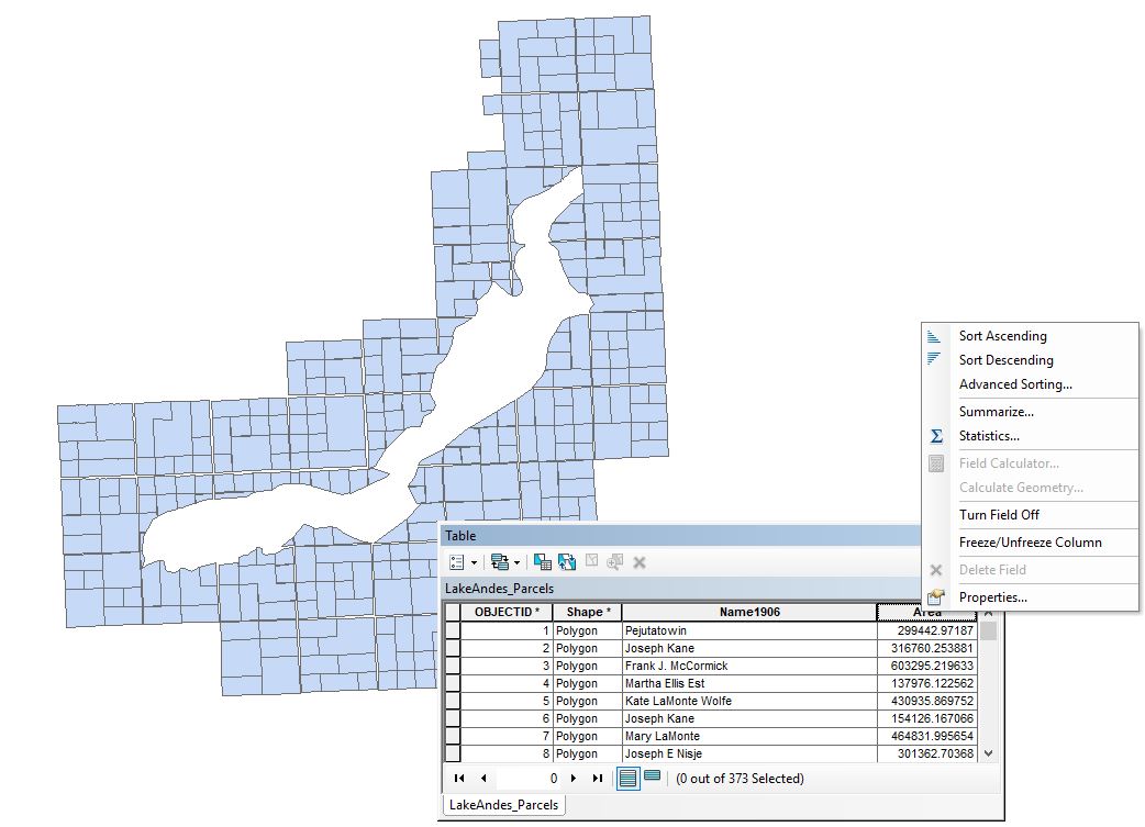
The teams were asked to calculate the area for each parcel for Lake Andes, SD, yet the Calculate Geometry option is not available. The problem evaluates the team members’ knowledge on geographic and projected coordinate systems (the latter is required to calculate area and distance), after a thorough investigation of the data layer properties.
Drone Thinking
Braving the winter elements, the class traveled to MacLeish Field Station for their first hands-on training after an initial introductory day. Despite frigid fingers and a moderately challenging NW wind at an advertised 8 mph, students rotated roles in a typical Smith flight team configuration: Pilot-in-Command, Camera Operator, and Visual Observer. Prior to arriving to the station, each student consulted the SAL’s pre-flight and safety checklists to develop their own appropriate guidelines to flying, as well as familiarizing themselves with relevant terms and viewed basic flight maneuvers. We practiced the operation processes under the watchful eyes of a porcupine vigorously eating a stick.
On our return, we took an opportunity to fly over the freshly snow covered campus and captured quite a few stunning images of Paradise Pond, the Dam, and Lamont Bridge.

In the lab, we discussed innovative drone applications in wildlife monitoring, humanitarian aid, law enforcement, and archeology. The class had conversations on the nuances of regulations and reflected upon how these policies affect aspiring remote pilots and the burgeoning community of drone enthusiasts (and un-enthusiasts). A thought-provoking exercise that could’ve been prompted by this fortune: “Would you like to do someone a favor…with drones?”
We concluded the class on Friday with a perfect score on DJI’s Knowledge Quiz before taking off on the athletic fields for basic flight maneuvers (squares, circles, and figure-eights). Students also explored various camera gimbal movements to reveal the most fitting shots for the landscape. The quiz tested the students’ FAA regulation knowledge with questions such as: What privacy laws apply to the operation of a drone? Under what circumstances can you exceed the maximum altitude allowed to fly according to the FAA?
The course was best summarized by a fortune cookie: “No need to worry! You will always have everything you need…with drones.”
You can read more about the Drone Thinking Initiative here.
** Note on references to fortunes and fortune cookies ** A SAL tradition begins every interterm class with fortune cookies. Each student is given a cooking and asked to read aloud their fortune with the addition of “with GIS”, or “with Drones” (depending on class). Surprisingly, the concatenated phrases make sense, more or less, and always generate some laughs. In some cases, they are spot on to our collective effort to learn and progress as critical thinkers.