Software Use & Access
ArcGIS is installed on all Science Center computers, including the SAL (SR104), and Neilson Digital Media Hub Computer Lab (Neilson 012D). There are two ways to use ArcGIS software outside of the SAL:
1. Remote access via Amazon AppStream - please contact CATS
2. Direct download
- PC users can download the installation files: ArcMap 10.8.2, ArcGIS Pro 3.0
- Mac users will need to install a Windows virtual machine such as VMware; please contact ITS. You can also use the open-source GIS software QGIS
You can access ArcGIS Online through Enterprise login using your Smith credentials
| ArcMap | ArcPro | ArcGIS Online | |
| Description | ArcMap is a desktop GIS program for cartography, geoprocessing/spatial analysis, and data management. | ArcPro is the latest desktop GIS program that has enhanced 3D and graphic capabilities, more interactive geoprocessing, and integration with ArcGIS Online. | ArcGIS Online is a collaborative web GIS where you can use, create, and share maps, 3D scenes, web applications, and data layers. |
| Platform | Desktop | Desktop | Web |
| Interface | Toolbar | Ribbon | Toolbar |
| Integration with ArcGIS Online | Limited - can access via add data from ArcGIS Online | Complete | n/a |
| Companion Applications | ArcCatalog, ArcScene, ArcGlobe | None, it's integrated | Commonly used: StoryMaps, Survey123 |
| Layout | Single | Multiple | Single |
| 3D | 3D Analyst extension | 3D Scene | 3D web Scene |
| Analysis Capacity | No limit | No limit | Consumes credits by capability (except for: create viewshed, create watersheds, trace downstream). There are finite credits allotted and each analysis/hosting consumes credits proportional to the magnitude of the datasets |
| Analysis Capabilities | Similar to ArcMap with naming/workflow changes. Notable difference from ArcMap: don't need to start/end editing session, can change database schema without using ArcCatalog | Limited | |
| User account | None | License tied to user; account generated by Enterprise login | Account tied to user; generated by Enterprise login |
| User privileges | Unrestricted | Unrestricted | Default is Publisher - can create maps, perform analysis, add items, share content, create groups, and publish features/map tiles as hosted web layers |
| Map file | Map Documents (.mxd) | Projects (.aprx) - which can include multiple maps | Cloud-hosted web map |
| Data Sharing | Local | Local and cloud-hosted (edit feature services on-the-fly) | Cloud hosted - can set access to indivial, Smith, or public |
You can sign in to ArcGIS Online through Enterprise login using your Smith credentials
Anytime you’re presented with the login page, expand Enterprise login and type in smithcollege, and use your Smith credentials when prompted

We have an Esri Education Institution License that covers college-related academic purposes like teaching and research (restrictive if administrative), and installation on personal devices, as long as you use it for learning purposes. Here’s the rubric for determining permitted uses under the Esri Education Institution License Program. If you have further clarifying questions, please contact Jon (jcaris@smith.edu) or Kala'i (lellis@smith.edu).
To collaborate outside of Smith with another organization that has an ArcGIS Online account, we can set up a Collaboration space for two organizations to edit content. Please contact Kala'i (lellis@smith.edu) with the following:
- A brief description/purpose of the project, who’s involved, the duration
- The other organization’s URL (for example, Smith’s organization URL is https://smithcollege.maps.arcgis.com/)
- What kinds of materials do you anticipate sharing – StoryMaps, data layers?
Your access is tied to your Smith credentials, so you won’t be able to login once your email expires. You can sign up for an ArcGIS for Personal Use subscription for $100/year to use ArcMap, ArcGIS Pro, and ArcGIS Online for personal, not-for-profit uses
If you’re a graduating student, you should consider the following:
1. Transfer collaborative content to a current user – if you own the content that was created as part of a collaboration (e.g. group project, faculty research), please organize items that need to be transferred in folders, and contact Kala'i (lellis@smith.edu) with the folder name and whom to transfer to
![]()
2. Transfer to your ArcGIS for Personal Use subscription – once you have your personal account, you can migrate the content using ArcGIS Online Assistant. For items that can’t be transferred with AGOL Assistant (such as StoryMaps) or if you need help, please contact Kala'i (lellis@smith.edu)
3. Transfer to another ArcGIS Online organization – if your future employer or institution has an ArcGIS Online account and allows your content to be transferred there, you can migrate the content using ArcGIS Online Assistant. For items that can’t be transferred with AGOL Assistant (such as StoryMaps) or if you need help, please contact Kala'i (lellis@smith.edu)
4. Delete – you can delete any content that you no longer need, and others are not dependent on (e.g. a web map that’s part of a StoryMap or web app)
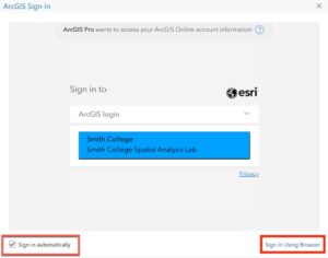
- OpenArcGIS Pro
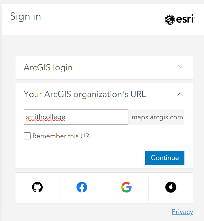
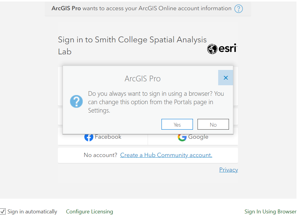
- Expand the drop down menu “Your ArcGIS organization’s URL”, type smithcollege as shown below, and click continue

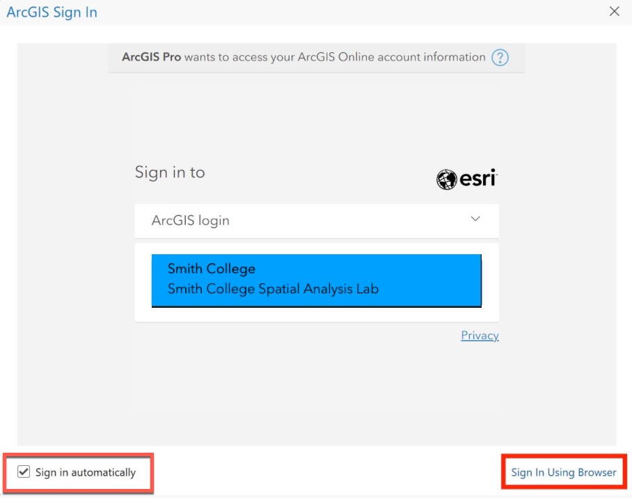
- Check the box in the bottom left hand corner and then click "Sign in using browser"
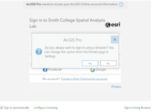
- If prompted with this pop up, select "Yes"
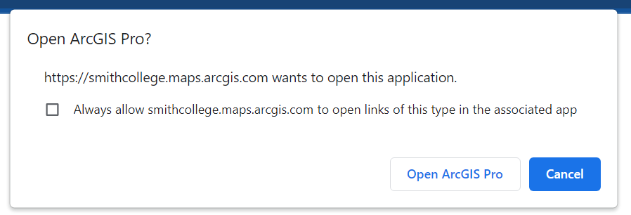
- After signing in with your Smith credentials and authenticating with DUO choose "Open ArcGIS Pro"

- You will need to repeat this process and authenticate each time you open ArcGIS Pro on a new computer
If you continue to have issues, reach out to Kala'i (lellis@smith.edu) for more help.
Spatial Data
Please contact Kala'i (lellis@smith.edu) to be added to the GIS users group. To connect to Q:/ and J:/:
- On a PC: File Explorer >> This PC >> Map Network Drive. Enter \\bass-nas\gis\gisdata for Q:/ and \\bass-nas\gis\gishome\username for J:/
- On a Mac: Connect to VPN. In Finder >> Go >> Connect to Server. Enter \\bass-nas\gis\gisdata to connect to Q:/ or \\bass-nas\gis\gishome\username for J:/
By default, ArcGIS saves your work on the local desktop (C:/). You should always indicate the output location of your files to be your personal workspace (J:/ drive) so that you can access your work from any computer on the campus network
As long as you save your work in your personal workspace (J:/ drive), your work will be preserved until you graduate (and indefinitely if you deposit your data). Your ArcGIS Online content is guaranteed to be saved while you’re at Smith, but not indefinitely after you graduate or otherwise leave (reference above section for transferring your content)
You can reference our finding spatial data workshop when searching for spatial data in general. Good authoritative sources to get started are: Esri’s Living Atlas for the World, MassGIS for Massachusetts, and the SAL’s Open Data Portal for Smith. You can consult with Kala'i (lellis@smith.edu) or Jon (jcaris@smith.edu) for help as well
Please fill out this metadata form and contact Kala'i (lellis@smith.edu) for help preparing your data
Learning Resources
The SAL is accessible during the Clark Science Center hours – Monday-Friday 7am-6pm, and any Smith student, staff, or faculty with a valid OneCard has card access Monday-Friday 6pm-11pm and weekends 8am-10pm. The Lab is available for use whenever there isn’t a class (please check our calendar). Jon and Kala'i have regular office hours and by appointment
You can sign up to receive the SAL’s mapmonsters Listserv for upcoming workshops and events. These are also posted on the lab’s calendar.
At Smith, there's one Intro to GIS class (GEO/ENV150) offered each fall that is taught with ArcGIS Pro. This is the most comprehensive way to learn the software, as well as its online counterparts like ArcGIS Online (for web-mapping), StoryMaps (location-based digital storytelling platform), and other data collection methods (GPS). There's also an Interterm Intro to GIS (IDP153) that's taught with QGIS.
You can get a sense of examples of how GIS has been incorporated into the curriculum from our semester reviews on classes/projects we worked on
You can cross-register within the Five Colleges, which offers equivalent and advanced spatial analysis courses. These are the fall 2020 courses as examples:
- Mount Holyoke College: GEOG210 GIS for Social Sciences & Humanities, GEO320 Research Methods with Geospatial Technology
- UMass Amherst: NRC585 Intro to GIS; Upper-/graduate-level: ECO697DD Spatial Databases & Data Interoperability, GEOGRAPH493S Spatial Decision Making & Support, GEOGRAPH691P GIS Programming, REGIONPL673 Spatial Analysis & Regional Development
Check out the learning resources page.
StoryMaps
Here's a step-by-step tutorial to get started with StoryMaps. Check the general FAQ for questions, and explore Esri resources and other stories for inspiration.
You can still edit existing classic story maps or make new ones, but classic story maps will only be supported until 2024; the stories will persist but no new updates.
An express map is a simple locator/distribution map that you can create within the StoryMap builder that you can draw features and annotate. It only exists within the StoryMap you’re working in as opposed to a web map that can be used in other StoryMaps and web apps. A web map can house layers, perform analysis, visualize, and prompt interactions with your narrative (such as map actions). We recommend using a web map where possible.
Contact Kala'i (lellis@smith.edu) to set up a Group in ArcGIS Online