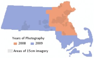
The 2008-2009 Orthophoto Imagery from MassGIS is now available for download.
Note that the Spatial Analysis Lab is currently downloading many of the orthophotos for our areas of interest (Northampton, Whately, etc.) and the complete statewide set will be available at:
gishomedataimages2008-2009Orthophotos (UNC path)
or
Q:Data2008-2009Orthophotos (convenient drive mapping used in the SAL)
Please do NOT download and save orthophotos on GEO without contacting the GIS Specialist.
Image / Raster Catalogs: Please note that you can use the image catalog files found in the same directory to easily load the orthophotos in ArcGIS. Image catalogs automatically load the orthophotos that cover your area of interest. More information on using image catalogs in ArcGIS can be found here. A quick video tutorial is also available from the Spatial Analysis Lab.
The catalog files are:
IMGCAT_COQ2008_2009SID_15CM.dbf – for 15 centimeter orthophotos, if available for your area of interest,
and,
IMGCAT_COQ2008_2009SID_30CM.dbf – for 30 centimeter orthophotos