
What happened?
- From 2006 to 2011, Syria (map below) experienced a major drought that resulted in an agricultural, economic and humanitarian crisis.
- Farmers became unable to grow crops and by 2007, wheat production had decreased by about 80%. By 2010, almost all livestock herds in the country had died.
- As a result of this agricultural crisis, by 2011, 1.5 million Syrians were forced to move from rural areas to cities in search of livelihoods. As of 2020, there were about 6.1 million internally displaced persons within Syria and about 5.5 million registered Syrian refugees in other nearby countries.
- The influx of people into cities caused food and water shortages, increases in food prices, and illness as urban areas experienced strains on their resources, and the government’s failure to provide adequate resources led to unrest.
- These events may have contributed to the start of the Syrian Civil War in 2011 and caused even more migration within and out of the country.
- Economic disaster also ensued as Syria relies heavily on its agricultural industry. In 2003, prior to the crisis, agriculture was about 25% of Syria’s gross domestic product (GDP), but by 2008, that number had been reduced to 17%. The country was forced to import wheat for the first time since the mid-1990s. Wheat, rice, and feed prices more than doubled and livestock production fell.
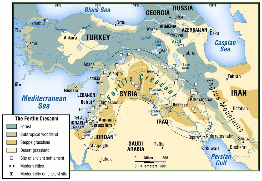
Map showing location of Syria on the east coast of the Mediterranean Sea in the portion of southwestern Asia known as the Middle East. Also indicated are the surrounding countries as well as the Fertile Crescent region, which is a crescent-shaped area with relatively fertile land where the first settled agricultural communities originated by the 9th millennium BCE (from Martin Sidwell.com, n.d.).
How is this related to climate?
- Syria has a naturally dry climate – only about 7.6% of the country’s land is irrigated, meaning that farmers rely on the climate, including temperature, yearly rainfall, and groundwater, to reap sufficient harvests each year – but from 2006 to 2011, the country experienced the worst drought it had seen in 900 years.
- The drought hit the northeastern “breadbasket” region within the Fertile Crescent (map above), which normally produces over two third of Syria’s crop yields, particularly hard.
- Climate change has been identified as one of the major factors contributing to the onset of this drought.
- The 2006-2011 drought was especially severe because of general climatic trends caused in part by anthropogenic climate change in the Fertile Crescent region of Syria (map above). From 1990 to 2010, a period in Earth’s history that has experienced large human-caused carbon emissions, average winter rainfall decreased, annual surface temperature increased and the Palmer Drought Severity Index (PDSI) decreased (the more negative the PDSI, the drier the region is) in the Fertile Crescent (figures below). Warming in the Fertile Crescent region has occurred more quickly than the change in global surface temperature, and much of this increase has occurred since 2000.
- There is debate among members of the scientific community as to whether and to what extent the drought, refugee crisis, and civil war in Syria have been caused by anthropogenic climate change. Studies which do not relate these events to climate change do not necessarily deny any of these connections. Instead, they simply do not find statistically significant relationships between these events and climate change.
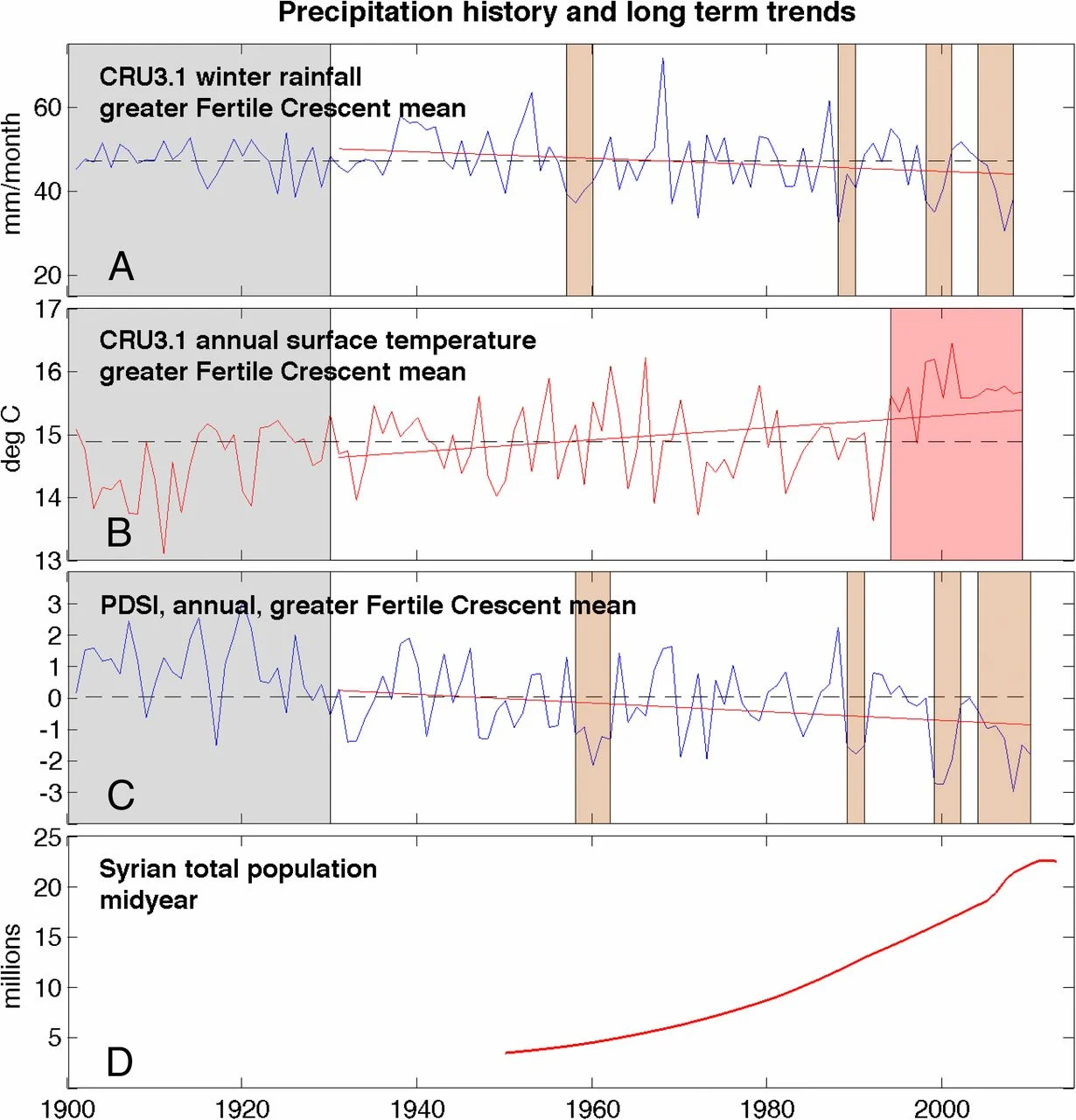
Average winter rainfall (graph A), annual surface temperature (graph B), annual Palmer Drought Severity Index (PDSI; graph C) for the Fertile Crescent region, and Syrian population from 1900 to 2010 (graph D; from Kelley and others, 2015). Note the following trends in the graphs(marked by straight red lines): a decrease in mean winter rainfall, an increase in mean annual surface temperature, and a decrease in the mean annual PDSI. Also note the increase in the Syrian population.
- The drought was also exacerbated by Syria’s large population (graph D above) and depleted groundwater. Syria’s population was at an all-time high during the drought so more people were affected compared with previously recorded severe droughts. Also, prior to the drought, the Syrian government implemented policies to increase agricultural production, such as land redistribution and irrigation projects, despite growing water scarcity. These policies depleted groundwater, preventing drought resilience.
References and additional resources
- Abraham, J. “Study finds that global warming exacerbates refugee crisis.” The Guardian. 2018. https://www.theguardian.com/environment/climate-consensus-97-per-cent/2018/jan/15/study-finds-that-global-warming-exacerbates-refugee-crises.
- Amery, H. A. “Climate, not conflict, drove many Syrian refugees to Lebanon.” The Conversation. 2019. https://theconversation.com/climate-not-conflict-drove-many-syrian-refugees-to-lebanon-127681.
- “Category Archives: Nation State.” Martin Sidwell.com. n.d. http://martinsidwell.com/category/nation-state/.
- Dai, A. “The Climate Data Guide: Palmer Drought Severity Index (PDSI).” National Center for Atmospheric Research. 2019. https://climatedataguide.ucar.edu/climate-data/palmer-drought-severity-index-pdsi.
- Gleik, P. H. “Water, drought, climate change, and conflict in Syria.” Weather, Climate and Society, vol. 6, no. 3, 2014, pp. 331-340. DOI: https://doi.org/10.1175/WCAS-D-13-00059.1.
- Hendrix, C. S. “A comment on ‘climate change and the Syrian civil war revisited.’” Political Geography, vol. 60, 2017, pp. 251-252. DOI: http://dx.doi.org/10.1016/j.polgeo.2017.06.010 0962-6298/
- Ide, T. “Climate war in the Middle East? Drought, the Syrian civil war, and the state of climate-conflict research.” Current Climate Change Reports, vol. 4, 2018, pp. 347-354.
- Kelley, C. P., et al. “Climate change in the Fertile Crescent and implications of the recent Syrian drought.” Proceedings of the National Academy of Sciences of the United States of America, vol. 112, no. 11, 2015, pp. 3241-3246. DOI: 10.1073/pnas.1421533112.
- Mansharamani, V. “A major contributor to the Syrian conflict? Climate change.” Public Broadcasting System. 2016. https://www.pbs.org/newshour/economy/a-major-contributor-to-the-syrian-conflict-climate-change.
- Sauter, M. B. and Comen, E. “Climate refugee crises are happening right now. Here’s how you can help.” USA Today. 2019. https://www.usatoday.com/story/money/2019/07/10/disease-flood-war-climate-refugee-crises-happening-now/39669605/.
- Selby, J., Dahi, O. S., Fröhlich, C., and Hulme, M. “Climate change and the Syrian civil war revisited.” Political Geography, vol. 60, 2017, pp. 232-244. DOI: https://doi.org/10.1016/j.polgeo.2017.05.007.
- “The World Factbook: Syria.” United States Central Intelligence Agency. 2020. https://www.cia.gov/the-world-factbook/countries/syria/.
- Ulker, D., Erguven, O., and Gazioglu, C. “Socio-economic impacts in a changing climate: Case study Syria.” International Journal of Environment and Geoinformatics (IJEGEO),vol. 5, no. 1, 2018, pp. 84-93. DOI: 10.30897/ijegeo.406273.
- World Bank Group. “Syria.” Climate Change Knowledge Portal. 2020. https://climateknowledgeportal.worldbank.org/country/syria/climate-data-historical.
- Worth, R. F. “Earth is parched where Syrian farmers thrived.” New York Times. 2010. https://www.nytimes.com/2010/10/14/world/middleeast/14syria.html.