
What happened?
- Between 1760 and 1860, western India (map below) experienced several periods of widespread famine.
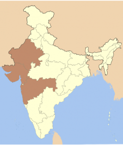
The region of western India is shaded in red (from Wikipedia, 2021).
-
- The famine of 1790 to 1792, caused by a crop failure that led to increased grain prices, was particularly devastating.
- The famine of 1812 hit the state of Gujarat (map below) especially hard since this region was also experiencing high rates of immigration from the neighboring state of Rajasthan, which had experienced crop failures the year before.
- The famine of 1842 was also particularly severe.
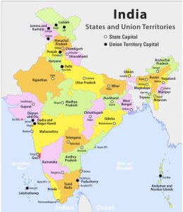
Map of the states and territories of India (from Wikipedia, 2021).
- The immediate response of a region’s government to the onset of a famine often determines its severity. The British East India Company, an imperial organization that started as a group of traders from Great Britain but began to forcibly seize territory and ended up ruling India in the 19th century, refused to intervene with the food market during the 1760-1860 famines. They believed that intervention by the government in the economy should be avoided, which exacerbated the famines.
How is this related to climate?
- The famines from 1760 to 1860 are correlated with several periods of widespread drought, throughout western India, the most drought-prone region of the country. There were 10 droughts in western India from 1792 to 1857 alone.
- A drought is a period of time when an area or region experiences below-normal precipitation. Droughts are associated with low soil moisture due to decreased precipitation and high evaporation rates caused by increased temperatures.
- Famines are often caused by, or are at least strongly correlated with, droughts because low soil moisture negatively impacts crop yields. Low soil moisture is caused by both lack of precipitation and increased evaporation rates due to high temperatures.
- Water availability in western India is heavily dependent on monsoon cycles. A monsoon cycle is a wet season and a dry season that are the result of changes in the direction of the prevailing winds of a region due to temperature and pressure differences between the land and ocean (diagram below).
- The south Asian monsoons in particular are caused by pressure and temperature differences between air masses over the Indian Ocean and the Asian continent.
- In the summer, high pressure is over the Indian Ocean and low pressure is over the Asian continent. Air moves from high to low pressure, so a moist air mass from over the Indian Ocean moves over the Asian continent, bringing torrential rains. These rains are characteristic of the wet season in south Asia, which usually lasts from June to September.
- In the winter, the conditions are reversed. High pressure is over the Asian continent and low pressure is over the Indian Ocean. A dry air mass from over the Asian continent moves over the Indian Ocean, resulting in the dry season.
- The south Asian monsoons in particular are caused by pressure and temperature differences between air masses over the Indian Ocean and the Asian continent.
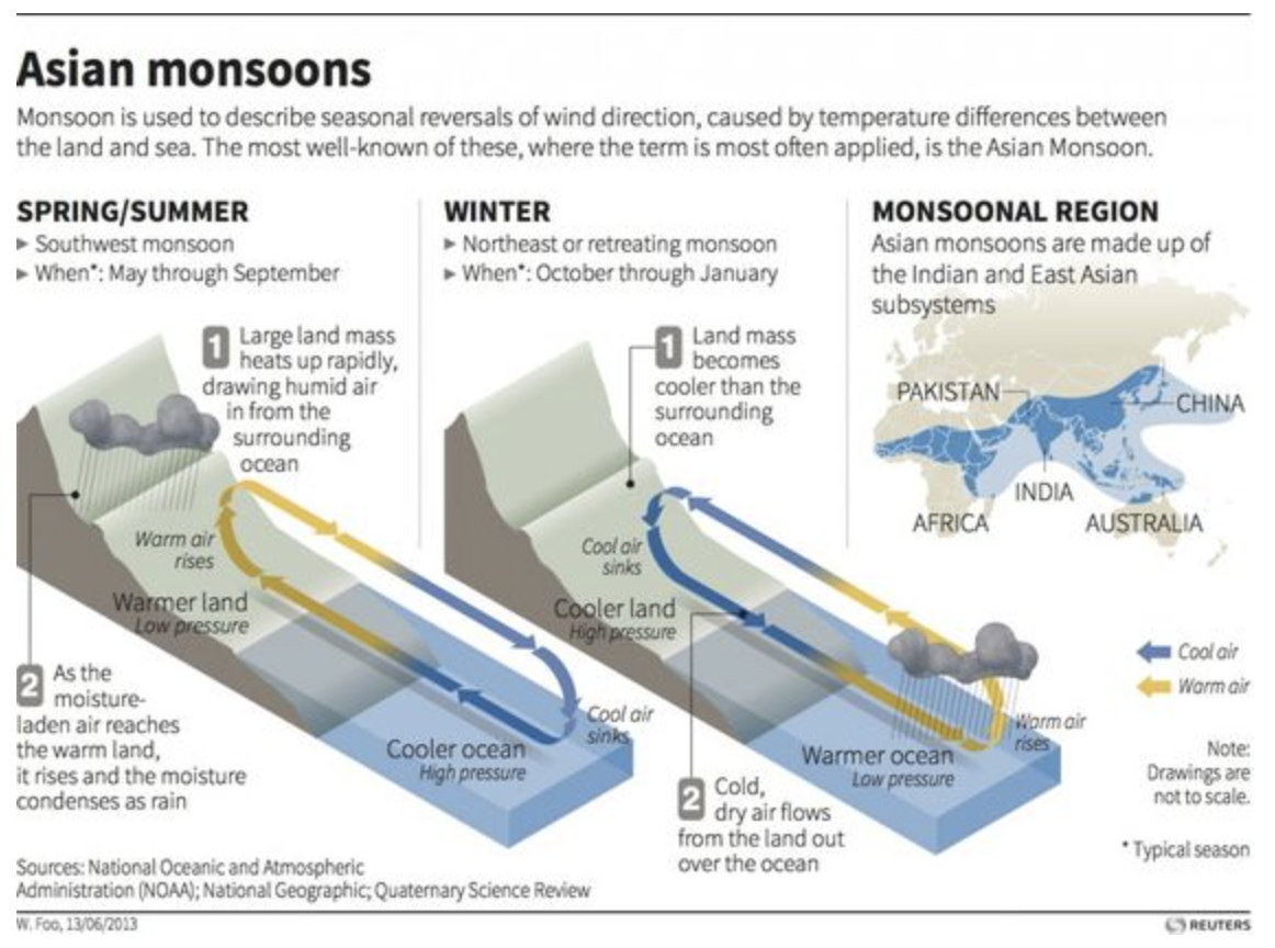
Monsoons are seasonal reversals of wind direction caused by temperature differences that occur primarily in Asia (from Wooster Geologists).
-
- Any changes to monsoon cycles, such as deficits (when the monsoon cycle starts later than usual or brings a lower than normal amount of rain), failures (when the monsoon does not form at all) or other extreme variability, may lead to drought. The main causes for monsoon variability in western India are:
- Fluctuations in air circulation patterns
- Air masses in south Asia moving from areas of high to low pressure are an important driver of the monsoon cycle (diagram above). Fluctuations in air circulation can affect these masses, which in turn impacts the monsoon and how much rain it brings to western India.
- El Niño Southern Oscillation (ENSO) (diagram below)
- El Niño, and its opposite phase, La Niña, are part of the El Niño-Southern Oscillation (ENSO) cycle, which is a complex, large-scale weather pattern driven by natural temperature variations in the Equatorial Pacific Ocean. El Niño phases are associated with warmer ocean temperatures and La Niña by colder ocean temperatures.
- The effects of ENSO on the South Asian monsoon are not completely understood, but drought is more likely during the El Niño phase and heavy precipitation is more likely during the La Niña phase.
- Fluctuations in air circulation patterns
- Any changes to monsoon cycles, such as deficits (when the monsoon cycle starts later than usual or brings a lower than normal amount of rain), failures (when the monsoon does not form at all) or other extreme variability, may lead to drought. The main causes for monsoon variability in western India are:
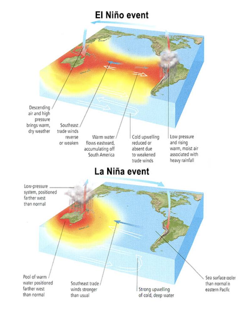
El Niño and La Niña are complex, large-scale weather patterns driven by natural temperature variations in the Equatorial Pacific (from Reef Resilience Network).
- Droughts continue to impact India’s population today: from 1990 to 2006, more than one billion people have been affected and more than 4 million have died. With ongoing global warming, monsoon patterns are expected to become more variable and the chance of severe drought in western India is expected to increase.
References and additional resources
- Adamson, G. C. D. “Institutional and community adaptation from the archives: A study of drought in western India 1790–1860.” Geoforum, vol. 55, 2014, pp. 110–119. DOI: https://doi.org/10.1016/j.geoforum.2014.05.010.
- Adamson, G. C. D. “‘The Most Horrible of Evils’: Social Responses to Drought and Famine in the Bombay Presidency, 1782–1857.” Natural Hazards and Peoples in the Indian Ocean World, 2016, pp. 79–104. DOI: https://doi.org/10.1057/978-1-349-94857-4_4.
- Crawford, A. “Climate Monday: Visualizing the South Asian Monsoon.” Wooster Geologists. https://woostergeologists.scotblogs.wooster.edu/2018/03/05/climate-monday-visualizing-the-south-asian-monsoon/
- Damodaran, V., et al. “The 1780s: Global Climate Anomalies, Floods, Droughts, and Famines.” The Palgrave Handbook of Climate History. Palgrave Macmillan, 2018.
- Doctor, V. “Recollecting India’s frantic efforts to end starvation after independence.” The Economic Times. 2020. https://economictimes.indiatimes.com/news/politics-and-nation/recollecting-indias-frantic-efforts-to-end-starvation-after-independence/articleshow/73618277.cms?from=mdr.
- “The El Niño/Southern Oscillation.” Penn State University College of Earth and Mineral Sciences. https://www.e-education.psu.edu/meteo469/node/211.
- Reef Resilience Network. “El Nino Southern Oscillation.” https://reefresilience.org/stressors/climate-and-ocean-change/el-nino-southern-oscillation/.
- Gadgil, S., et al. “Droughts of the Indian summer monsoon: Role of clouds over the Indian Ocean.” Current Science, vol. 85, no. 12, 2003, pp. 1713–1719. https://www.jstor.org/stable/24109976.
- Gupta, A., et al. “Drought disaster challenges and mitigation in India: strategic appraisal.” Current Science, vol. 100, no. 12, 2011, pp. 1795–1806. https://www.semanticscholar.org/paper/Drought-disaster-challenges-and-mitigation-in-Gupta-Tyagi/26a80661809f756fd84cfacecebcf4cea5e0f3b7.
- Kumar, K. K., et al. “On the Weakening Relationship Between the Indian Monsoon and ENSO.” Science, vol. 284, no. 5423, 1999, pp. 2156–2159. DOI: https://doi.org/10.1126/science.284.5423.2156.
- L’Heureux, M. “What is the El Niño – Southern Oscillation (ENSO) in a Nutshell?” NOAA Climate.gov. 2014. https://www.climate.gov/news-features/blogs/enso/what-el-ni%C3%B1o%E2%80%93southern-oscillation-enso-nutshell.
- McAlpin, M. B. “Dearth, Famine, and Risk: The Changing Impact of Crop Failures in Western India, 1870-1920.” The Journal of Economic History, vol. 39, no. 1, 1979, pp. 143–157.
- McNamara, R. “East India Company.” ThoughtCo. 2020. https://www.thoughtco.com/east-india-company-1773314.
- Rosenberg, M. “Monsoon.” ThoughtCo. 2017. https://www.thoughtco.com/what-is-a-monsoon-p2-1435342.
- Rutledge, K., et al. “Monsoon.” National Geographic. 2011. https://www.nationalgeographic.org/encyclopedia/monsoon/.
- Myhrvold-Hanssen, T. L. “Democracy, News Media, and Famine Prevention: Amartya Sen and The Bihar Famine of 1966-67.” 2003. https://www.semanticscholar.org/paper/Democracy-%2C-News-Media-%2C-and-Famine-Prevention-%3A-Myhrvold-Hanssen/d7631692434958ebf02bf4921b5888a25b04ece6.
- National Geographic Society. “Drought.” National Geographic. 2020. https://www.nationalgeographic.org/encyclopedia/drought/.
- Oblack, R. “Monsoons and Their Effect on the Environment.” ThoughtCo. 2019. https://www.thoughtco.com/what-is-a-monsoon-3444088.
- Prabhakar, S. V. R. K., and Shaw, R. “Climate change adaptation implications for drought risk mitigation: a perspective for India.” Climatic Change, vol. 88, no. 2, 2008, pp. 113–130. DOI: https://doi.org/10.1007/s10584-007-9330-8.
- Roy, T. “Were Indian Famines ‘Natural’ Or ‘Manmade’?” London School of Economics and Political Science, no 243, 2016. https://www.lse.ac.uk/Economic-History/Assets/Documents/WorkingPapers/Economic-History/2016/WP243.pdf.
- Relph, S. “Indian villages lie empty as drought forces thousands to flee.” The Guardian. 2019. https://www.theguardian.com/world/2019/jun/12/indian-villages-lie-empty-as-drought-forces-thousands-to-flee.
- Shi, F., et al. “A tree-ring reconstruction of the South Asian summer monsoon index over the past millennium.” Scientific Reports, vol. 4, no. 1, 2014. DOI: https://doi.org/10.1038/srep06739.
- “States and Union Territories of India.” Wikipedia. 2021. https://en.wikipedia.org/wiki/States_and_union_territories_of_India.
- “Western India.” Wikipedia. 2021. https://en.wikipedia.org/wiki/Western_India.