
What is happening?
- Since the year 2000, the southwestern United States has experienced extreme drought conditions (map below). Researchers claim that this megadrought is the region’s driest period in the past 1,200 years and expect that this will continue for another one to seven years, into the middle to late 2020s.
- The U.S. southwest does historically experience periods of extreme wet and dry periods. However, this uncharacteristic period of drought is a trend of intense dry conditions and abnormally high heat. Average daily temperatures between 2000 and 2020 were almost 1.1°C degrees higher than they were in 1950.
- Researchers traced the history of drought conditions in the region using local tree rings as a climate proxy. By analyzing tree rings, they could infer annual levels of soil moisture over the last 1,200 years. The study concluded that the period between 2000 and 2022 was the driest 22-year period since the 9th century.
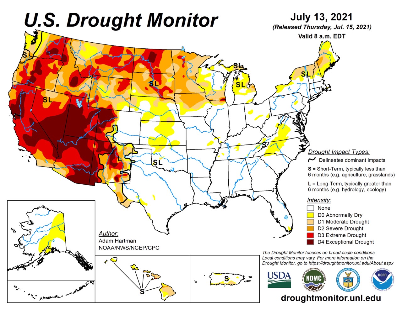
Map of drought intensity in the continental United States of America in June 2021. The year 2021 exhibited the most extreme drought conditions of the 22-year-long megadrought. Western states, extending from Canada to Mexico, have been the most affected (National Drought Mitigation Center, 2021).
How is this related to climate?
- Rising temperatures and modifications in moisture patterns due to human-induced or anthropogenic climate change have exacerbated the effects of the megadrought. Scientists from the University of California in Los Angeles approximate that hotter temperatures have contributed to a 42% worsening of the drought’s effects.
- Climate change is disrupting the water cycle: higher surface temperatures are related to increased evaporation. Global warming is also changing the predictability of wind patterns and ocean currents. As a result, precipitation in the U.S. west is becoming more infrequent. The precipitation record reveals longer periods of drought with shorter heavy rainfall events, meaning this region is receiving lots of moisture at once, or none at all. Current climate change is strengthening atmospheric rivers, which are temporary narrow belts of concentrated moisture in the atmosphere. Atmospheric rivers bring a lot of water from the tropical Pacific Ocean to the southwestern U.S. and can cause major flooding and landslides in coastal California.
- Researchers from Columbia University in New York City state that several consecutive years of high moisture are needed to end the megadrought. Despite several heavy rainfall events in 2022 in the American southwest, it is unlikely that it’ll be enough to end prolonged drought conditions unless substantial precipitation patterns continue.
- Megadrought events have occurred naturally in the southwestern U.S. Climate records show evidence of extreme drought events in the 1100s, 1200s, and 1500s, though less intense than the ongoing megadrought. However, human-induced climate change has heightened the severity of the megadrought. Scientists estimate that without the effects of anthropogenic climate change, the current drought would have been much less extreme.
- The effects of the anthropogenic climate change-induced megadrought have been referred to as the aridification of the West (see image below). Low levels of soil moisture due to increased evaporation and decreased precipitation have caused massive tree die-offs. Drought conditions put a strain on forest health, leaving large areas of trees vulnerable to pests and diseases. Consequently, areas dominated by dead forests have a high mass of dry, flammable wood and are prone to uncontrollable wildfires.
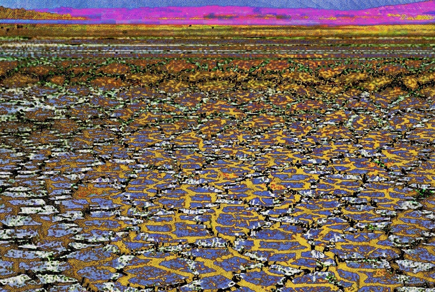
“Drought” by Alisa Singer, an artistic visualization of scorched and fractured dry soil inspired by the aridification of the western U.S. This piece is part of the artist’s series Environmental Graphiti, a collection of over 75 digital artworks aimed at raising awareness and educating the public about various environmental issues.
- One of the most concerning effects of the southwestern U.S. megadrought is water loss. Since the 1920s, the flow rate of the Colorado River has decreased by over 15% despite a small net increase in average annual precipitation.
-
- Global warming has reduced the mass of snowpacks by increasing rates of melting and evaporation. This is not good for regional moisture retention because snowpacks act as a water reservoir. Normally, snowpacks provide temporary relief during warmer periods by melting and hydrating surrounding areas. Mountain snowmelt is an essential part of the western U.S. water cycle during the summer and runoff from the mountains feeds the Colorado River when precipitation is lower.
- Due to global warming, winters in the western U.S. are becoming more mild. Warmer winters mean more precipitation in the form of rain instead of snow. Consequently, mountain snowpacks diminish every year, causing less moisture during the summer. Evaporation rates are also rising as global warming elevates annual ground temperatures. In addition to not receiving enough water, this region can retain less water in the summer, further exacerbating the megadrought.
- Over 40 million people are reliant on the Colorado River for water. Besides daily use, the Colorado River supplies the agriculture industry in seven U.S. states and northern Mexico. The Colorado River Compact of 1922 allotted 17.5 million acre-feet or 21.6 billion cubic meters of water to these regions annually. However, since 2000, the Colorado River’s mean flow rate has been less than 12.4 million acre-feet or 15.3 billion cubic meters, meaning that water use has well exceeded the river’s capacity.
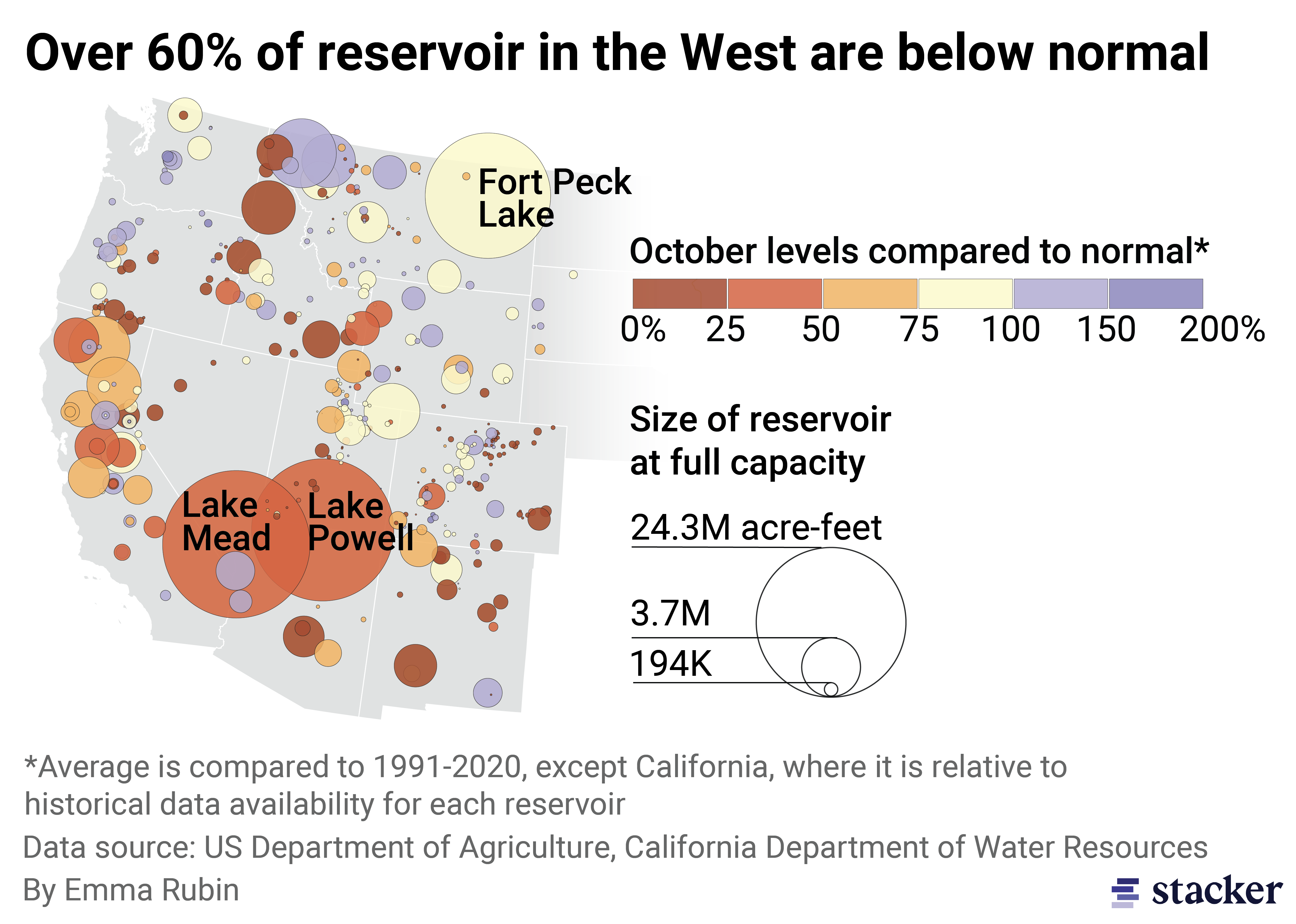
Map of lake reservoir capacity in the western U.S. in 2020 compared to water levels in 1991. Warmer colors represent reservoirs most affected by drought. The size of the circles indicates the maximum amount of water each lake has historically held. Notably, the Lake Powell water levels have dropped significantly in 2022 (Stacker, 2022).
- Furthermore, lakes in the western United States are also drying up as a result of the megadrought (map above). For instance, Lake Mead (located in northwestern Arizona and southeastern Nevada) and Lake Powell ( in northern Arizona and southern Utah) are at risk of reaching ‘dead pool status,’ where the water levels are too low to produce hydroelectric energy. Since 2000, Lake Mead has dropped 94 feet or 29 meters. Even more concerningly, Lake Powell’s water level has dropped 60 feet or 18 meters since 2020. Consequently, dams produce less hydropower, increasing the West’s reliance on non-renewable energy sources.
- The southwestern U.S. megadrought is also threatening agriculture by baking the earth and rapidly degrading soil (“Drought” art piece by Alisa Singer above). Periods of higher heat remove moisture from the earth, compacting the ground and preventing water from penetrating the ground. This is posing a major threat to crops and agricultural productivity (photograph below). Unless the agriculture industry switches to more drought-resistant native plants, aridification rates are expected to skyrocket in the next few decades.
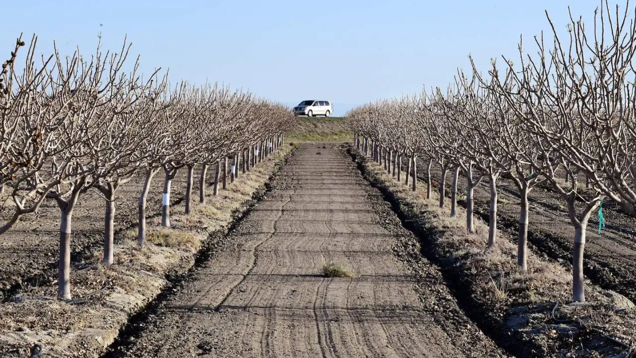
Photograph of an orchard in San Joaquin Valley, California in April 2021 after a year of historically low winter precipitation (Overpeck, 2021). Normally, this area is very productive and a major exporter of fruit and nuts.
References and additional resources
- Associated Press. “Biden administration proposes water cuts to avert Colorado River crisis.” NBC News. 2023. https://www.nbcnews.com/science/environment/biden-adminstration-proposes-water-cuts-avert-colorado-river-crisis-rcna79246.
- Canon, G. “US issues western water cuts as drought leaves Colorado River near ‘tipping point.’” The Guardian. 2022. https://www.theguardian.com/us-news/2022/aug/16/drastic-water-cuts-expected-as-megadrought-grips-western-us-states.
- City of Las Vegas. “Lake Mead Water Shortage.” City of Las Vegas. 2022. https://www.lasvegasnevada.gov/News/Blog/Detail/lake-mead-water-shortage.
- Columbia Climate School. “Megadrought in Southwest Is Now the Worst in at Least 1,200 Years, Study Confirms.” Columbia Climate School: Climate, Earth, and Society. 2022. https://news.climate.columbia.edu/2022/02/14/megadrought-in-southwest-is-now-the-worst-in-at-least-1200-years-study-confirms/.
- Easterling, D.R., Kunkel, K.E., Arnold, J. R. Knutson, T. LeGrande, A.N. Leung, L.R. Vose, R. S. Waliser, D.E. and Wehner, M.F. “2017: Precipitation change in the United States.” Climate Science Special Report: Fourth National Climate Assessment. 2017. https://science2017.globalchange.gov/chapter/7/.
- Irfan, U. “How the Western drought is pushing the power grid to the brink.” Vox Media. 2022. https://www.vox.com/23292669/drought-2022-power-energy-grid-lake-mead-climate-heat-hoover-dam.
- James, I. “Western megadrought is worst in 1200 years, intensified by climate change, study finds.” LA Times. February 2022. https://www.latimes.com/environment/story/2022-02-14/western-megadrought-driest-in-1200-years.
- “Map Archive.” U.S. Drought Monitor. 2023. https://droughtmonitor.unl.edu/Maps/MapArchive.aspx.
- Montgomery, D. R. “Desertification is turning the Earth barren– but a solution is still within reach.” The Guardian. 2021. https://www.theguardian.com/commentisfree/2021/sep/02/desertification-barren-solution-famine-agriculture.
- Overpeck, J. “Extreme heat and the ongoing aridification of the West.” The Hill. 2021. https://thehill.com/opinion/energy-environment/560591-extreme-heat-and-the-ongoing-aridification-of-the-west/.
- Palmer, B. “Climate Change is Drying Out the American West.” Natural Resources Defense Council. 2020. https://www.nrdc.org/stories/climate-change-drying-out-american-west.
- Singer, A. “Drought.” Environmental Graphiti. 2021. https://eg-v2.squarespace.com/all-series/drought.
- Stacker. “A Look at the West’s Megadrought.” ABC Local News 8. https://localnews8.com/stacker-science/2022/11/03/a-look-at-the-wests-megadrought/.
- UN. “As the Climate Dries the American West Faces Power and Water Shortages, Experts Warn.” UNEP, 2022. https://www.unep.org/news-and-stories/story/climate-dries-american-west-faces-power-and-water-shortages-experts-warn.
- Williams, A.P., Cook, B. Smerdon, J. “Rapid intensification of the emerging southwestern North American megadrought in 2020-2021.” Nature Climate Change. 12. 2022. 232-234. https://www.nature.com/articles/s41558-022-01290-z.
- Xiao, M. Udall, B., and Lettenmaier, D. “On the Causes of Declining Colorado River Streamflows.” Water Resources Research, vol. 54, no. 9, 20 Aug. 2018, pp. 6739–6756., https://doi.org/10.1029/2018wr023153.