
What happened?
- Around 14,000 BCE, people migrated from Siberia (Asia) to Alaska (North America) over the Bering Land Bridge (map below).
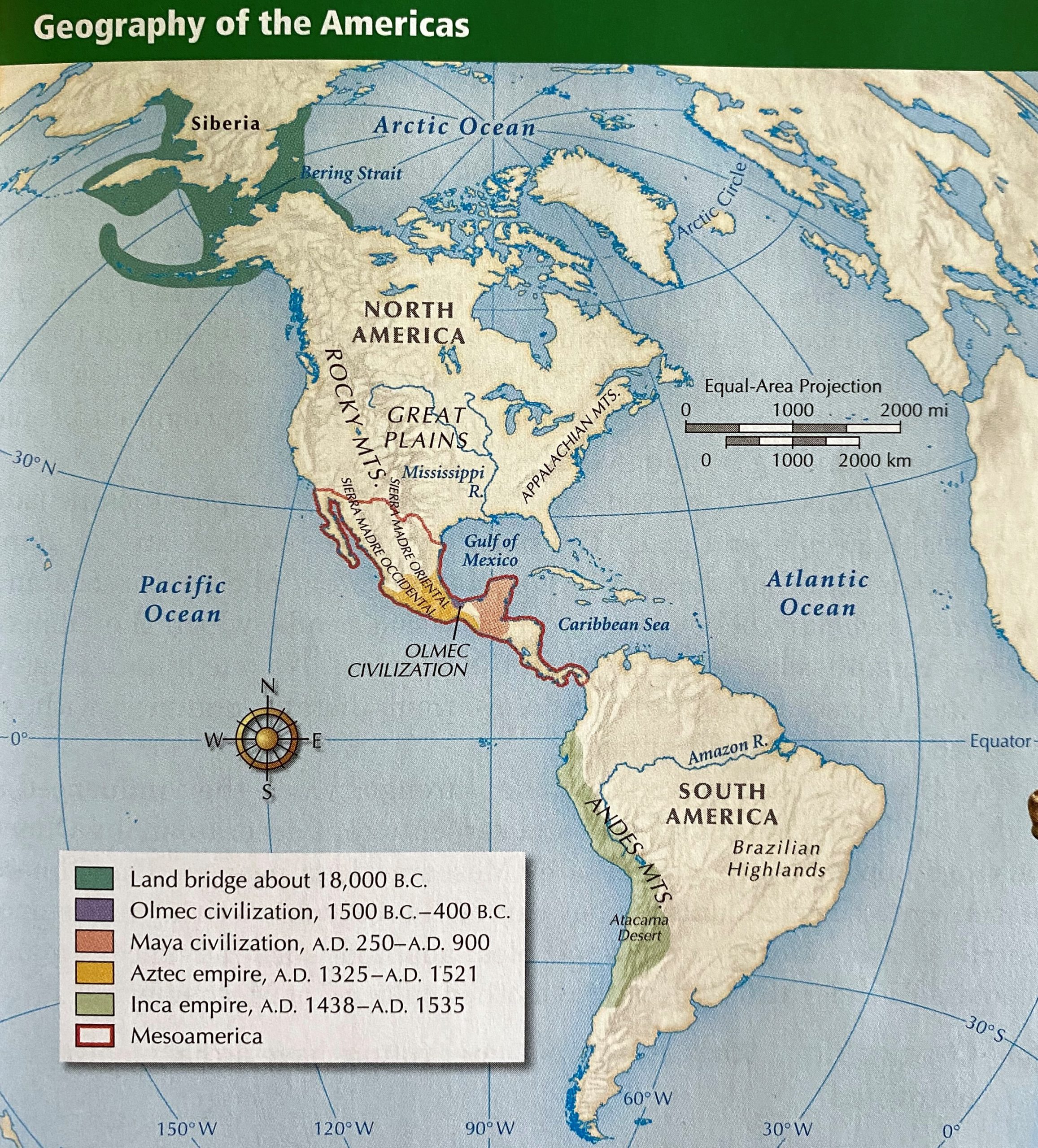
Map of the Americas. The Bering Land Bridge between Asia and North America in 18,000 BCE is shown in dark green. The map also shows the extent of ancient civilizations in Central or Mesoamerica (Ellis and Esler, 2014).
How is this related to climate?
- During the last ice age, which peaked around 19,000 BCE and ended around 8,700 BCE, global sea levels were up to 100 meters lower than they are today because colder temperatures resulted in large amounts of water becoming frozen in glaciers.
- The Bering Land Bridge existed during this time of low sea levels. When the glaciers melted and sea levels rose to their present-day position, the land bridge flooded and formed the Bering Strait that now separates Asia from North America. See below for an interactive map of the Bering Land Bridge and the Bering Strait over time.
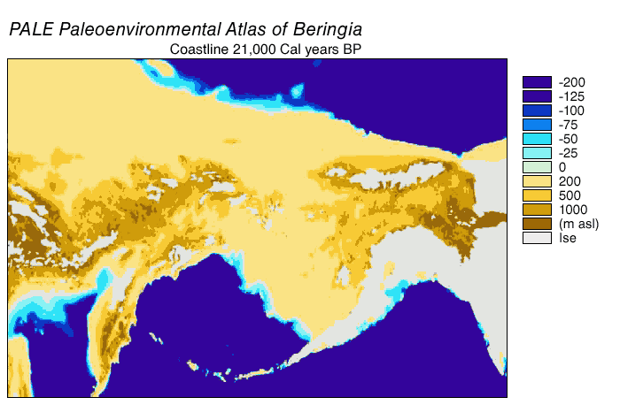
Map of the Bering Strait and the Bering Land Bridge over time (Cal years BP: “calibrated years before the present” or “calendar years before the present”) (from Wood, 2020).
Further Exploration
- New evidence found in Chiquihuite Cave, Mexico, including tools made from a type of limestone not originating from the cave itself, suggests that humans first arrived in North America possibly as far back as 28,000 BCE. At that time, the ice sheets covering North America during the last ice age were still extensive, which would have made cross-continental travel very difficult, and suggests that the Pacific coast was the more probable travel route. This idea is known as the Pacific Coastal Route Hypothesis.
- This new research indicates that even though people likely reached North America no later than 24,500 to 17,000 BCE, occupation did not become widespread until the very end of the last ice age, around 12,700 to 10,900 BCE.
- This new evidence dispels the Clovis-first model, named for evidence of human occupation in Clovis, New Mexico. This model suggests that the first people to reach North America traveled across the Bering Land Bridge and then into North America along an ice-free cross-continental corridor around 14,000 to 8,000 BCE (map below). It is likely that by then North America had already been occupied by people who migrated via the Pacific coastal route.
- Under the Pacific Coastal Route Hypothesis, people traveled south along the “kelp highway” of the western coast of the Americas because it was mainly ice-free and therefore easier to traverse than the ice-covered inland areas (map below). The coastal waters had common giant kelp species such as Durvillaea antarctica and Macrocystis pyrifera, which supported rich ecosystems that provided food, such as sea bass, cod, rockfish, sea urchins, abalones, and mussels for the migrating people. At the end of the last ice age, glaciers melted and sea levels rose, flooding the “kelp highway.”
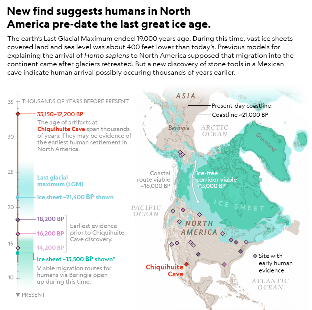
Map of North America during the Last Glacial Maximum, depicting both the coastal route suggested by the Pacific Coastal Route Hypothesis and the ice-free corridor route suggested by the Clovis-first model. Chiquihuite Cave is marked in red (from Gandy, 2020, National Geographic Magazine).
- After the initial migrations to North America, people began moving southward, following the Pacific coast from Alaska to Chile. Those who made it to northern and central South America were limited to small communities because the cold, harsh climate of the ice age prevented populations from expanding. A short period of rising temperatures and retreating glaciers followed, which allowed people to migrate further south and establish new settlements in Patagonia, such as in Monte Verde (map below). Then, around 12,500 BCE, in what is known as the Antarctic Climate Reversal, temperatures dropped as much as 6℃ below present-day and remained low for 2 millenia. When temperatures rose yet again, more glaciers melted, flooding the Strait of Magellan and cutting the southernmost settlements on Tierra del Fuego off from the mainland (map below), leading to a cultural division between mainland and coastal inhabitants.
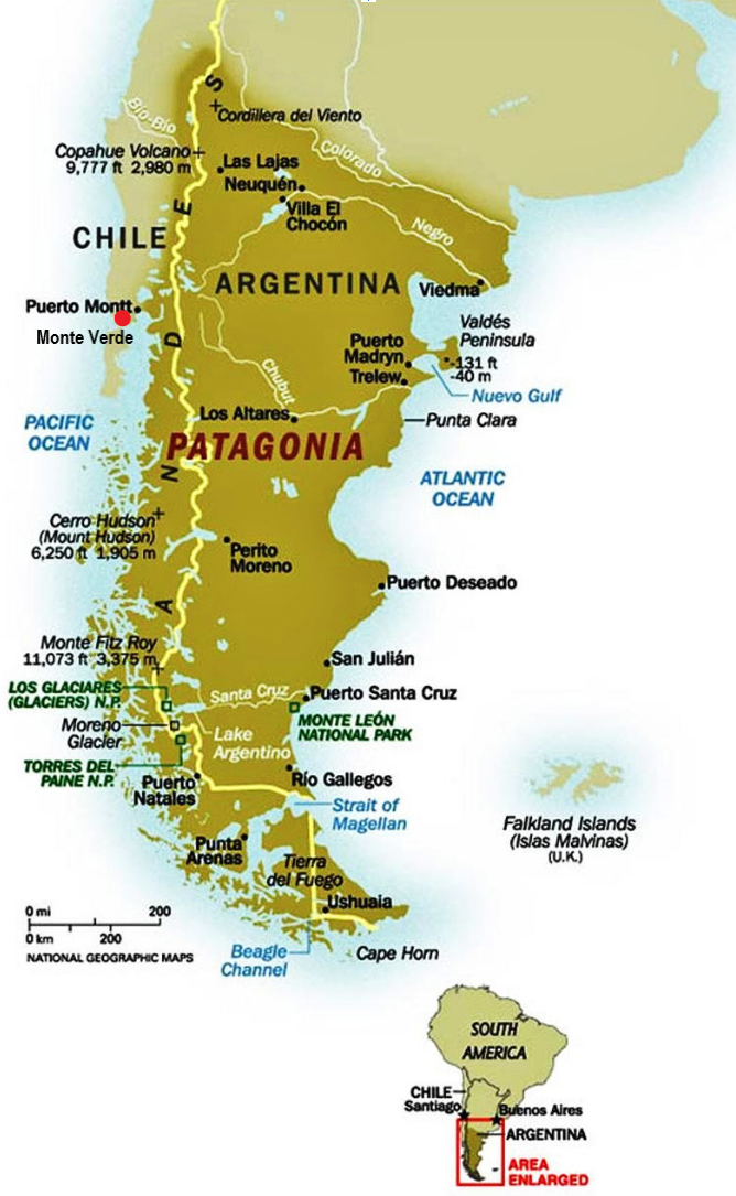
Map of southern South America. The Patagonia region is shown in dark brown. Monte Verde, located on the western coast, is marked with a red dot. The Strait of Magellan, marked in blue, and Tierra del Fuego are at the southern tip of the continent (from Salbuchi, 2010).
References and additional resources:
- Ardelean, C. F., et al. “Evidence of human occupation in Mexico around the Last Glacial Maximum” Nature, vol. 584, no. 7819, 2020, pp. 87–92. DOI: 10.1038/s41586-020-2509-0.
- Bacerra-Valdivia, L. and Higham, T. “The timing and effect of the earliest human arrivals in North America.” Nature, vol. 584, 2020, pp. 93-97. https://www.nature.com/articles/s41586-020-2491-6.
- Daley, J. “First Humans Entered the Americas Along the Coast, Not Through the Ice.” Smithsonian. 2016. www.smithsonianmag.com/smart-news/humans-colonized-americas-along-coast-not-through-ice-180960103/.
- Daley, J. “New Evidence Shows That Humans Could Have Migrated to the Americas Along the Coast.” Smithsonian. 2018. www.smithsonianmag.com/smart-news/new-evidence-shows-first-americans-could-have-migrated-along-coast-180969217/.
- Dvorsky, G. “Humans Reached North America 10,000 Years Earlier Than We Thought, New Research Suggests.” Gizmodo. 2020. www.gizmodo.com/humans-reached-north-america-10-000-years-earlier-than-1844466373.
- Ellis, E. G. and Esler, A. High School World History (Pearson Student Edition, Survey Grade 9/12). Wilmington, Prentice Hall, 2014.
- Gandy, D. “Surprise Cave Discoveries May Double the Time People Lived in the Americas.” National Geographic. 2020. www.nationalgeographic.com/history/2020/07/surprise-chiquihuite-cave-discovery-mexico-double-peopling-americas/?cmpid=org.
- Geggel, L. “Humans Crossed the Bering Land Bridge to People the Americas. Here’s What It Looked Like 18,000 Years Ago.” LiveScience. 2019. www.livescience.com/64786-beringia-map-during-ice-age.html.
- Hirst, K. “Some of the Earliest Colonists to America Followed the Pacific Rim.” ThoughtCo. 2019. www.thoughtco.com/pacific-coast-migration-model-prehistoric-highway-172063.
- History.com Editors. “Ice Age.” History. 2015. ww.history.com/topics/pre-history/ice-age.
- Moen, J. World Map. 2020, www.worldatlas.com/aatlas/infopage/magellan.htm.
- “Other Migration Theories.” National Park Service. 2017. www.nps.gov/bela/learn/historyculture/other-migration-theories.htm.
- Prothero, D. R. and Dott, R. H. Evolution of the Earth (8th ed). New York, McGraw-Hill Education, 2010.
- Salbuchi, A. “Argentina Targeted by World Government – Danger Over Patagonia.” 2010. www.bibliotecapleyades.net/sociopolitica/sociopol_globalelite_la57.htm.
- Wood, G. D. “The Greatest Journey of All Time.” Nautilus. 2020. www.nautil.us/issue/87/risk/the-greatest-journey-of-all-time?mc_cid=8d57e79ff5.