ARS388
From the course catalog:
This course considers architecture as a socially constructed place. We will examine how to analyze and intervene within the built environment. A final project, involving the manipulation/examination/interpretation of place and space through modeling and graphic communication or a multi-media research project will be required. Prerequisites: ARS 283, 285, and two art history courses, or permission of the instructor. Enrollment limited to 12. A required fee of $75 to cover group supplied materials and/or printing will be charged at the time of registration. Students will be responsible for directly purchasing any additional supplies that may be required.
- Spring 2015: 5 students
- Spring 2014: 10 students
- Spring 2013: 9 students
Resources
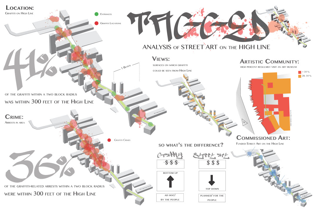
updated February 2015
GIS @ Smith
- ArcGIS Map Document (download and open with ArcGIS Desktop ver. 10.2)
- Public Information App (includes Social Media)
ESRI
- ESRI Community Analyst
- ESRI ArcGIS Online (aka ArcGIS.com)
- Story Maps (along the High Line)
- Solar Analyst (map and analyze the effects of the sun over a geographic area for specific time periods)
NYC GIS Data from various NY Sites
- NYC Open Data
- NYC Department of City Planning
- CUGIR
- NYC Library – Map Warper – Georeference Historic Maps
- NYCMap (direct link to study area)
- NYC Oasis Map (Community Maps)
- Block by block demographic changes from Center for Urban Research
new as of Feb 26, 2013
- Bicycle (and other data feeds) – http://www.nyc.gov/html/dot/html/about/datafeeds.shtml#Bikes
- MTA data developer feeds (subway ridership, etc.)
EPA – Environmental Justice
- EJView (direct link to study area)
Historical GIS Data
- National Historic Geographic Information System : Data Finder User Guide (pdf)
- Horse Stables (interesting bit of research…. maybe more for fun)
- Social Explorer (contemporary and historic demographic data & visualization)
- David Rumsey Map Collection
Crowd Sourced Data
- City Sourced (zooms to Chelsea neighborhood)
Google Maps
Metadata for data layers used in ArcMap document
Spring 2014 Description & Resources
For the Spring 2014 semester, the Spatial Analysis Lab worked with the ARS-388 class for a day, providing an interactive demonstration of desktop and web GIS technologies, with the goal of encouraging students to use spatial data to both optimize and contextualize their final project building design plans. We illustrated the “layer-cake” concept of curating GIS data relevant to a project in order to visualize architectural problems and solutions using a map of Northampton spatial data in ArcGIS, then introduced two web-based mapping systems that allowed students to explore these ideas without needing any software or technical GIS knowledge:
Some Final Projects – 2013