We’re excited to announce our first Mystery Map Competition of 2016! Like the carillon map, we used CartoDB to make this an interactive mystery map. Click on the image below to see the full thing. Once you have an idea of what this map might be showing, use the form below to submit your guess. Good luck! [123-contact-form […]
Category Archives: Mystery Map
December Mystery Map winners
Out of the 70 people who viewed our Musical Mystery Map in December, eight sent in answers, and nearly all of them got at least a part of the question right. So, in order of submission, here’s who correctly guessed that the size of the bubbles represented number of bells: Leslie Vicente Soto Anonymous (we […]
December Mystery Map Unveiled!
Step aside Facebook, Instagram, and Buzzfeed: procrastinate productively and challenge your spatial reasoning skills with the SAL’s latest Mystery Map Competition! This Mystery Map is an interactive, multimedia map developed using CartoDB. We recommend taking some time to explore the map to see if that helps you answer the following questions: 1. What can you find […]
November Mystery Map Wrap-Up
Our November Mystery Map has been live for three weeks, and since most Smithies are now concentrating more on procrastinating finals than on last month’s election, we’ve decided it’s time to wrap up the competition. As a reminder, here’s what the Mystery Map looked like: As another reminder, we issued a hint ten days ago that […]
Tofurky Animation
We’re thrilled by how many responses we got to our 2nd annual Tofurky Map. Almost 200 people posted to the map, and over 1,250 people viewed it! We created an animated map showing submissions over the week of Thanksgiving. We used a very cool tool called Torque from CartoDB, […]
November Mystery Map Hint
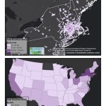
We’ve decided to give all of our faithful blog readers a hint to help you along in our most recent Mystery Map Competition. Think of it as an early holiday gift or a generous helping of Thanksgiving leftovers. This map shows some kind of election data. That’s why Scott had to get the data from the […]
November Mystery Map
In celebration of Geo Week and GIS Day, we’re happy to announce another Mystery Map competition! Scott put together this map after paying a visit to the city clerk earlier this week. Click here for a higher resolution version of the map (in PDF format). (Read about October Mystery Map/Data answer)
Fall 2015 Mystery Map Data Revealed!
Members of the Smith Community seem quite adept at interpreting LiDAR Point Cloud Cross Sections! Nearly eight (80) folks viewed the challenge and eight (8) submitted answers. Of those, five were completely correct, and the remaining three missed one or two. Surprisingly, the Cutter-Ziskind profile (C) was mistaken most often with answers of Mendenhal, and Sabin-Reed/McConnell. The […]
Fall 2015 Mystery Map-Data
We have cool, shiny new LiDAR data to play with in the Spatial Analysis Lab. These data were captured in December 2013, but we did not receive the final product until earlier this summer. We’ll provide more details about LiDAR, and our plans for processing and analysis after the Mystery Map competition is complete. Until […]
Winter Mystery Map Revealed
Answer Revealed: As many of you successfully guessed — our winter mystery map, themed: Annual Valley Event, was mapping… Valley Gives Day 2014! Making the Map The first map produced was the one used as the winter mystery map. […]