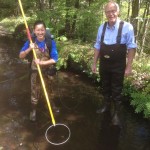
Two weeks ago, the SAL team headed to Popham Beach State Park, Maine, with Prof. Bob Newton’s Geomorphology class. Bob has taken his Geomorphology class there for several years to assess erosion at the beach. A major erosion event in the mid 2000s threatened the park’s facilities and nearby homes, which were previously shielded from […]
Category Archives: Classes
Story Maps in the Classroom
Maps are increasingly popular as storytelling tools in the world of digital media – just a glance at the homepages of the New York Times, The Atlantic, or the Huffington Post confirms that. We’ve experienced this wave of mapping enthusiasm in the SAL, and it’s already started changing how we teach GIS. Moreso than conventional GIS maps, Story […]
Interterm GIS Course
Like most years, the SAL team taught a week-long GIS course during interterm to give a GIS jumpstart to students who want to learn what GIS is all about but can’t take (or haven’t yet taken) the semester-long GIS course. This year, however, we made some big changes to our curriculum that we’re pretty excited […]
Senior Week Workshops
Calling all aspiring cartographers and spatial thinkers! Interested in developing your map-making skills? Have some spare time during Senior Week? The Spatial Analysis Lab would like to invite Smith students, faculty, staff, and community to join us for a series of informal mapping workshops Tuesday – Friday of Senior Week (5/12-5/15). The workshops are open […]
Interterm Course 2015 — Recap
The Spatial Analysis Lab was excited to kick of 2015 with an intro to GIS interterm course in the first week of January Term! 14 students joined us in the SAL for 5 days of GIS exploration with ArcGIS. The course was structured around the development of key GIS skills. Each day focused on one or […]
November in Review
Well, November was quite a busy month. So busy, in fact, that we were unable to spend time writing weekly updates to post. Our review covers the entire month of November and is organized by type of work: Overview Class Support 1. Study of Women and Gender 230 2. Spaces of Mexico (SoMec) 3. ENV201/202 4. Soc232 Student […]
Last Week Review (October 13th-17th)
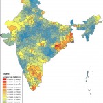
Participations from the SAL during the week of October 13th-17th: 1. Lying with Maps: initial lab session with ENV311 2. Meeting with Lewis Global Studies Center about Study Abroad data 3. Ebola Mapping Workshop at Amherst College 4. Finalized India Rainfall Maps with Economics Professor Vis Taraz 5. One-on-one sessions with “mappers” from Study of […]
Four Weeks In
Four Weeks In: So much Accomplished, but OH So Much More to Do The fall semester is in full swing, and the Spatial Analysis Lab (SAL) is feeling the heat of the ever quickening pace across campus. The month of September has been packed full of workshops, class support, individual faculty and student support, new […]
News Update: End of Fall 2013 Semester
Somehow, the Fall 2013 semester is already drawing to a close. The past few weeks have been a whirlwind of student projects and preparations for some exciting things coming in 2014. Several classes this semester had major final projects that involved spatial data and GIS analysis. First, of course, the final projects for the Introductory […]
ENV 201/202, Fall 2013
Food Desert Interactive Maps: USDA Food Environment Atlas: http://www.ers.usda.gov/data-products/food-environment-atlas/go-to-the-atlas.aspx#.UmrR3fmKLAk USDA Food Access Research AtlasL http://www.ers.usda.gov/data-products/food-access-research-atlas/go-to-the-atlas.aspx#.UmrAWfmKLAl ESRI Food Desert Finder: http://megacity.esri.com/fooddeserts/#-10570450.2925;4722931.8985;10 Another version of the same map: http://www.arcgis.com/explorer/?open=153c17de00914039bb28f6f6efe6d322 Social Explorer: http://www.socialexplorer.com/89AACD3A4F1E4E1/explore Things to think about while exploring the maps: How are the creators of this map defining a “food desert”? What spatial data are they including in their criteria? Is the […]