The nose of a plunging anticline is the dip slope of the resistant rock unit so it tends to have a long smooth nose (example from Millheim PA 15' map). The length of the nose is a function of the steepness of the plunge. Steeply plunging anticlines will have shorter noses than gently plunging anticlines. the nose of a plunging syncline is the obsequent slope of the resistant rock unit so it tends to have a short steep nose (example from Millheim PA 15' ma).
|
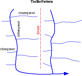
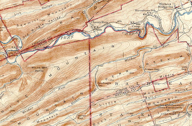
Trellis style drainage networks dominate in folded rock terrains.Streams can be classified as obsequent - flowing opposite to the dip direction, consequent, flowing parallel to the dip direction and subsequent streams flow parallel to the direction of strike. The obsequent streams are generally short and steep while the consequent streams are longer. |
Plattekill Creek is also capturing part of the Gooseberry system. Note the "barbed" tributary entering from the vicinity of the Platte Clove PO. Also note the drainage divide between Plattekill Creek and Gooseberry Creek which is located within the valley. The steeper gradient of Plattekill Creek will allow it to grow westward by headward erosion causing more and more capture of Gooseberry Creek .
Judson and Kauffman (1990) show how stream piracy has created a series of wind gaps along the Blue Ridge Mountains. In Figure 1 Beaverdam Creek, Gap Run and Goose Creek have been superimposed onto the Blue Ridge creating a series of water gaps. The Shenandoah River is a small tributary to the Potomac. In Figure 2 the Shenandoah has captured the headwaters of Beaverdam Creek. The capture occurred because the Potomac, being large was able to relatively easily erode down through the Blue Ridge. Since the Potomac served as the local base level for the Shenandoah, the Shenandoah also eroded downward and headward. Beaverdam Creek being smaller was not able to erode through the Blue Ridge as fast and was therefore susceptable to capture. Figures 3 and 4 show subsequent capture of the headwaters of Gap Run and Goose Creek as well. The abandoned water gaps became elevated by continued erosion of the less resistant rocks on either side of the Blue Ridge. These wind gaps today provide for easy transportation routes across the Blue Ridge.
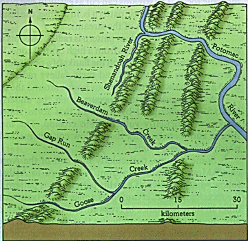 |
Stage 1 - Beaverdam Creek, Gap Run, and Goose Creek flow eastward through the Blue Ridge and enter the Potomac. (from Judson and Kauffman) |
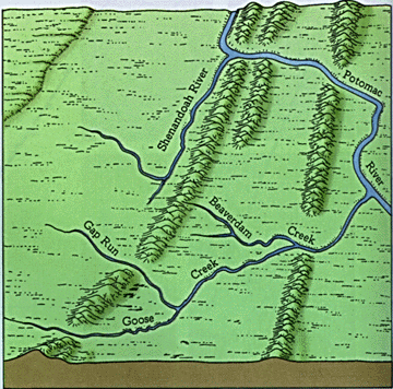 |
Stage 2 - As the land is eroded downward, the three east flowing creeks do not have the power to erode as far through the Blue Ridge as the Shenandoah, Potomac system. The Shenandoah extends itself southward by headward erosion through the relatively high land west of the Blue Ridge. It eventually captures Beaverdam Creek. (from Judson and Kauffman) |
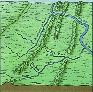 |
Stage 3 - The capture of Beaverdam Creek added more discharge to the Shenandoah which was able to therefore erode more. Headward erosion leads to the capture of Gap Run. The water gaps where Beaverdam Creek and Gap Run used to flow through the Blue Ridge are left as wind gaps. (from Judson and Kauffman) |
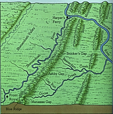 |
Stage 4 - Eventually Goose Creek is captured as well. Snicker's Gap, Ashby Gap, and Manassas Gap are left as wind gaps. As the land on either side of the ridge is eroded down together with the ridge summit, the relative elevation of the wind gaps becomes higher and higher. (from Judson and Kauffman)
|
 |  |
|
 |
 |
 |