|
|
|
|||||||||||||||
| |
|
|||||||||||||||
| |
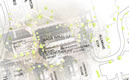
The map below demonstrates overlaying more recent (2005) tiled imagery onto Google Maps. The updated portion covers Smith Campus. As you move to the edge of campus, you should notice the image transition to the 2001 aerial photograph. Enjoy
|
| Home Maps & Data Classes Research News Connections |
© Copyright
2003 Spatial Analysis Lab All rights reserved. |